Maps showing data from the 1572 Ottoman fiscal survey


Total tax

1572, Total tax, Proportional symbols
1572 Ottoman fiscal survey Total_tax Proportional symbols Symbol size is relative to the magnitude of each feature attribute. Yekün akçe value Harokopio University Sylvia Ioannou foundation Economy, environment, and landscape in the Cypriot longue durée
1572, Total tax, Hot spot analysis (Getis-Ord Gi* statistic)
1572 Ottoman fiscal survey Total_tax Kernel density Hot spot analysis (Getis-Ord Gi* statistic) Hot spots indicate significant clustering of high values and cold spots indicate significant clustering of low values. Yekün akçe value Harokopio University Sylvia Ioannou foundation Economy, environment, and landscape in the Cypriot longue durée
1572, Total tax, Aggregated in various regions of the island
1572 Ottoman fiscal survey Total_tax Aggregated in 1885 subdistricts Subdistricts 1885 (Kitchener's map) Modern districts Height zones Geographic regions Yekün akçe value Harokopio University Sylvia Ioannou foundation Economy, environment, and landscape in the Cypriot longue durée
1572, Total tax, Aggregated in major drainage basins
1572 Ottoman fiscal survey Total_tax Aggregated in major drainage basins Yekün akçe value Harokopio University Sylvia Ioannou foundation Economy, environment, and landscape in the Cypriot longue durée
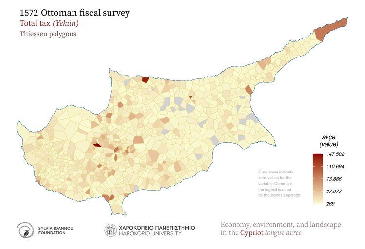
1572, Total tax, Thiessen polygons
1572 Ottoman fiscal survey Total_tax Thiessen polygons Gray areas indicate zero values for the variable. Comma in the legend is used as thousands separator Yekün akçe value Harokopio University Sylvia Ioannou foundation Economy, environment, and landscape in the Cypriot longue durée
1572, Total tax, Spatial autocorrelation (Moran's I statistic)
1572 Ottoman fiscal survey Total_tax Spatial autocorrelation (Moran's I) A high-high cluster is an area with high value surrounded by areas with high values. LISA: Local Indicators οf Spatial Association Yekün akçe value Harokopio University Sylvia Ioannou foundation Economy, environment, and landscape in the Cypriot longue durée
1572, Total tax, Aggregated in 25 sq.km hexagons
1572 Ottoman fiscal survey Total_tax Aggregated in 25 Km^2 hexagons Comma in the legend is used as thousands separator Yekün akçe value Harokopio University Sylvia Ioannou foundation Economy, environment, and landscape in the Cypriot longue durée
1572, Total tax, Aggregated in 25 sq.km rectangles
1572 Ottoman fiscal survey Total_tax Aggregated in 25 Km^2 rectangles Comma in the legend is used as thousands separator Yekün akçe value Harokopio University Sylvia Ioannou foundation Economy, environment, and landscape in the Cypriot longue durée
1572, Total tax, Kernel density
1572 Ottoman fiscal survey Total_tax Kernel density Shades of red color indicate high density of the mapped variable Yekün akçe value Harokopio University Sylvia Ioannou foundation Economy, environment, and landscape in the Cypriot longue durée

Households

1572, Households, Proportional symbols
1572 Ottoman fiscal survey Households Proportional symbols Symbol size is relative to the magnitude of each feature attribute. Hane number amount Harokopio University Sylvia Ioannou foundation Economy, environment, and landscape in the Cypriot longue durée
1572, Households, Hot spot analysis (Getis-Ord Gi* statistic)
1572 Ottoman fiscal survey Households Kernel density Hot spot analysis (Getis-Ord Gi* statistic) Hot spots indicate significant clustering of high values and cold spots indicate significant clustering of low values. Hane number amount Harokopio University Sylvia Ioannou foundation Economy, environment, and landscape in the Cypriot longue durée
1572, Households, Aggregated in various regions of the island
1572 Ottoman fiscal survey Households Aggregated in 1885 subdistricts Subdistricts 1885 (Kitchener's map) Modern districts Height zones Geographic regions Hane number amount Harokopio University Sylvia Ioannou foundation Economy, environment, and landscape in the Cypriot longue durée
1572, Households, Aggregated in major drainage basins
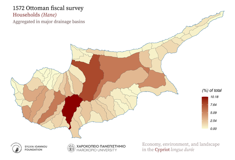
1572 Ottoman fiscal survey Households Aggregated in major drainage basins Hane number amount Harokopio University Sylvia Ioannou foundation Economy, environment, and landscape in the Cypriot longue durée
1572, Households, Thiessen polygons
1572 Ottoman fiscal survey Households Thiessen polygons Gray areas indicate zero values for the variable. Comma in the legend is used as thousands separator Hane number amount Harokopio University Sylvia Ioannou foundation Economy, environment, and landscape in the Cypriot longue durée
1572, Households, Spatial autocorrelation (Moran's I statistic)
1572 Ottoman fiscal survey Households Spatial autocorrelation (Moran's I) A high-high cluster is an area with high value surrounded by areas with high values. LISA: Local Indicators οf Spatial Association Hane number amount Harokopio University Sylvia Ioannou foundation Economy, environment, and landscape in the Cypriot longue durée
1572, Households, Aggregated in 25 sq.km hexagons
1572 Ottoman fiscal survey Households Aggregated in 25 Km^2 hexagons Comma in the legend is used as thousands separator Hane number amount Harokopio University Sylvia Ioannou foundation Economy, environment, and landscape in the Cypriot longue durée
1572, Households, Aggregated in 25 sq.km rectangles
1572 Ottoman fiscal survey Households Aggregated in 25 Km^2 rectangles Comma in the legend is used as thousands separator Hane number amount Harokopio University Sylvia Ioannou foundation Economy, environment, and landscape in the Cypriot longue durée
1572, Households, Kernel density
1572 Ottoman fiscal survey Households Kernel density Shades of red color indicate high density of the mapped variable Hane number amount Harokopio University Sylvia Ioannou foundation Economy, environment, and landscape in the Cypriot longue durée

Wheat

1572, Wheat, Proportional symbols
1572 Ottoman fiscal survey Wheat Proportional symbols Symbol size is relative to the magnitude of each feature attribute. Hınta kile (keyl) weight Harokopio University Sylvia Ioannou foundation Economy, environment, and landscape in the Cypriot longue durée
1572, Wheat, Hot spot analysis (Getis-Ord Gi* statistic)
1572 Ottoman fiscal survey Wheat Kernel density Hot spot analysis (Getis-Ord Gi* statistic) Hot spots indicate significant clustering of high values and cold spots indicate significant clustering of low values. Hınta kile (keyl) weight Harokopio University Sylvia Ioannou foundation Economy, environment, and landscape in the Cypriot longue durée
1572, Wheat, Aggregated in various regions of the island
1572 Ottoman fiscal survey Wheat Aggregated in 1885 subdistricts Subdistricts 1885 (Kitchener's map) Modern districts Height zones Geographic regions Hınta kile (keyl) weight Harokopio University Sylvia Ioannou foundation Economy, environment, and landscape in the Cypriot longue durée
1572, Wheat, Aggregated in major drainage basins
1572 Ottoman fiscal survey Wheat Aggregated in major drainage basins Hınta kile (keyl) weight Harokopio University Sylvia Ioannou foundation Economy, environment, and landscape in the Cypriot longue durée
1572, Wheat, Thiessen polygons
1572 Ottoman fiscal survey Wheat Thiessen polygons Gray areas indicate zero values for the variable. Comma in the legend is used as thousands separator Hınta kile (keyl) weight Harokopio University Sylvia Ioannou foundation Economy, environment, and landscape in the Cypriot longue durée
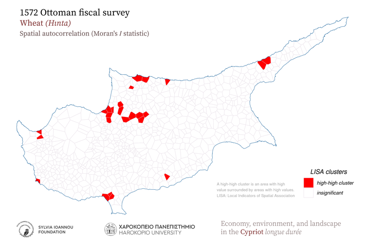
1572, Wheat, Spatial autocorrelation (Moran's I statistic)
1572 Ottoman fiscal survey Wheat Spatial autocorrelation (Moran's I) A high-high cluster is an area with high value surrounded by areas with high values. LISA: Local Indicators οf Spatial Association Hınta kile (keyl) weight Harokopio University Sylvia Ioannou foundation Economy, environment, and landscape in the Cypriot longue durée
1572, Wheat, Aggregated in 25 sq.km hexagons
1572 Ottoman fiscal survey Wheat Aggregated in 25 Km^2 hexagons Comma in the legend is used as thousands separator Hınta kile (keyl) weight Harokopio University Sylvia Ioannou foundation Economy, environment, and landscape in the Cypriot longue durée
1572, Wheat, Aggregated in 25 sq.km rectangles
1572 Ottoman fiscal survey Wheat Aggregated in 25 Km^2 rectangles Comma in the legend is used as thousands separator Hınta kile (keyl) weight Harokopio University Sylvia Ioannou foundation Economy, environment, and landscape in the Cypriot longue durée
1572, Wheat, Kernel density
1572 Ottoman fiscal survey Wheat Kernel density Shades of red color indicate high density of the mapped variable Hınta kile (keyl) weight Harokopio University Sylvia Ioannou foundation Economy, environment, and landscape in the Cypriot longue durée

Barley

1572, Barley, Proportional symbols
1572 Ottoman fiscal survey Barley Proportional symbols Symbol size is relative to the magnitude of each feature attribute. Şair kile (keyl) weight Harokopio University Sylvia Ioannou foundation Economy, environment, and landscape in the Cypriot longue durée
1572, Barley, Hot spot analysis (Getis-Ord Gi* statistic)
1572 Ottoman fiscal survey Barley Kernel density Hot spot analysis (Getis-Ord Gi* statistic) Hot spots indicate significant clustering of high values and cold spots indicate significant clustering of low values. Şair kile (keyl) weight Harokopio University Sylvia Ioannou foundation Economy, environment, and landscape in the Cypriot longue durée
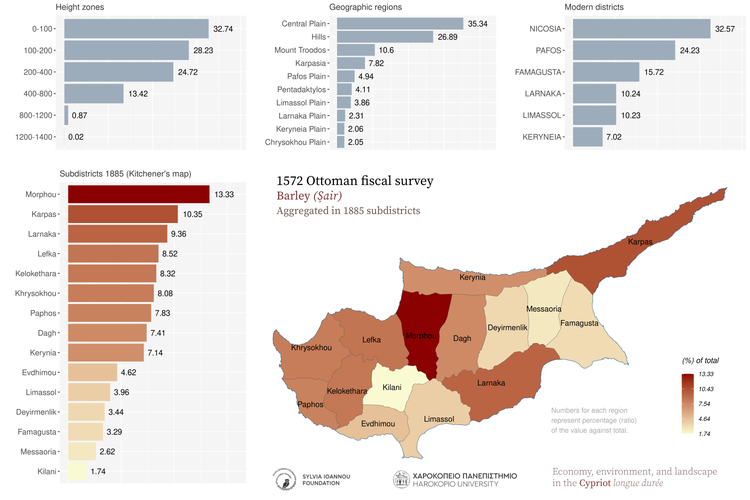
1572, Barley, Aggregated in various regions of the island
1572 Ottoman fiscal survey Barley Aggregated in 1885 subdistricts Subdistricts 1885 (Kitchener's map) Modern districts Height zones Geographic regions Şair kile (keyl) weight Harokopio University Sylvia Ioannou foundation Economy, environment, and landscape in the Cypriot longue durée
1572, Barley, Aggregated in major drainage basins
1572 Ottoman fiscal survey Barley Aggregated in major drainage basins Şair kile (keyl) weight Harokopio University Sylvia Ioannou foundation Economy, environment, and landscape in the Cypriot longue durée
1572, Barley, Thiessen polygons
1572 Ottoman fiscal survey Barley Thiessen polygons Gray areas indicate zero values for the variable. Comma in the legend is used as thousands separator Şair kile (keyl) weight Harokopio University Sylvia Ioannou foundation Economy, environment, and landscape in the Cypriot longue durée
1572, Barley, Spatial autocorrelation (Moran's I statistic)
1572 Ottoman fiscal survey Barley Spatial autocorrelation (Moran's I) A high-high cluster is an area with high value surrounded by areas with high values. LISA: Local Indicators οf Spatial Association Şair kile (keyl) weight Harokopio University Sylvia Ioannou foundation Economy, environment, and landscape in the Cypriot longue durée
1572, Barley, Aggregated in 25 sq.km hexagons
1572 Ottoman fiscal survey Barley Aggregated in 25 Km^2 hexagons Comma in the legend is used as thousands separator Şair kile (keyl) weight Harokopio University Sylvia Ioannou foundation Economy, environment, and landscape in the Cypriot longue durée
1572, Barley, Aggregated in 25 sq.km rectangles
1572 Ottoman fiscal survey Barley Aggregated in 25 Km^2 rectangles Comma in the legend is used as thousands separator Şair kile (keyl) weight Harokopio University Sylvia Ioannou foundation Economy, environment, and landscape in the Cypriot longue durée
1572, Barley, Kernel density
1572 Ottoman fiscal survey Barley Kernel density Shades of red color indicate high density of the mapped variable Şair kile (keyl) weight Harokopio University Sylvia Ioannou foundation Economy, environment, and landscape in the Cypriot longue durée

Vetch

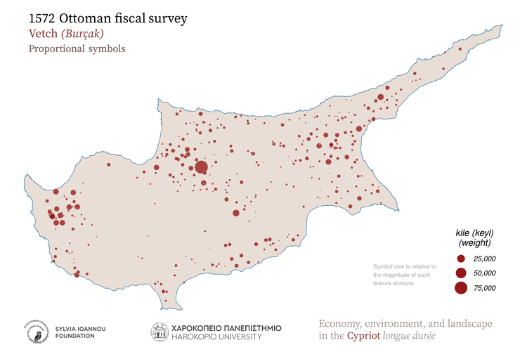
1572, Vetch, Proportional symbols
1572 Ottoman fiscal survey Vetch Proportional symbols Symbol size is relative to the magnitude of each feature attribute. Burçak kile (keyl) weight Harokopio University Sylvia Ioannou foundation Economy, environment, and landscape in the Cypriot longue durée
1572, Vetch, Hot spot analysis (Getis-Ord Gi* statistic)
1572 Ottoman fiscal survey Vetch Kernel density Hot spot analysis (Getis-Ord Gi* statistic) Hot spots indicate significant clustering of high values and cold spots indicate significant clustering of low values. Burçak kile (keyl) weight Harokopio University Sylvia Ioannou foundation Economy, environment, and landscape in the Cypriot longue durée
1572, Vetch, Aggregated in various regions of the island
1572 Ottoman fiscal survey Vetch Aggregated in 1885 subdistricts Subdistricts 1885 (Kitchener's map) Modern districts Height zones Geographic regions Burçak kile (keyl) weight Harokopio University Sylvia Ioannou foundation Economy, environment, and landscape in the Cypriot longue durée
1572, Vetch, Aggregated in major drainage basins
1572 Ottoman fiscal survey Vetch Aggregated in major drainage basins Burçak kile (keyl) weight Harokopio University Sylvia Ioannou foundation Economy, environment, and landscape in the Cypriot longue durée
1572, Vetch, Thiessen polygons
1572 Ottoman fiscal survey Vetch Thiessen polygons Gray areas indicate zero values for the variable. Comma in the legend is used as thousands separator Burçak kile (keyl) weight Harokopio University Sylvia Ioannou foundation Economy, environment, and landscape in the Cypriot longue durée
1572, Vetch, Spatial autocorrelation (Moran's I statistic)
1572 Ottoman fiscal survey Vetch Spatial autocorrelation (Moran's I) A high-high cluster is an area with high value surrounded by areas with high values. LISA: Local Indicators οf Spatial Association Burçak kile (keyl) weight Harokopio University Sylvia Ioannou foundation Economy, environment, and landscape in the Cypriot longue durée
1572, Vetch, Aggregated in 25 sq.km hexagons
1572 Ottoman fiscal survey Vetch Aggregated in 25 Km^2 hexagons Comma in the legend is used as thousands separator Burçak kile (keyl) weight Harokopio University Sylvia Ioannou foundation Economy, environment, and landscape in the Cypriot longue durée
1572, Vetch, Aggregated in 25 sq.km rectangles
1572 Ottoman fiscal survey Vetch Aggregated in 25 Km^2 rectangles Comma in the legend is used as thousands separator Burçak kile (keyl) weight Harokopio University Sylvia Ioannou foundation Economy, environment, and landscape in the Cypriot longue durée
1572, Vetch, Kernel density
1572 Ottoman fiscal survey Vetch Kernel density Shades of red color indicate high density of the mapped variable Burçak kile (keyl) weight Harokopio University Sylvia Ioannou foundation Economy, environment, and landscape in the Cypriot longue durée

Oats

1572, Oats, Proportional symbols
1572 Ottoman fiscal survey Oats Proportional symbols Symbol size is relative to the magnitude of each feature attribute. Alef kile (keyl) weight Harokopio University Sylvia Ioannou foundation Economy, environment, and landscape in the Cypriot longue durée
1572, Oats, Hot spot analysis (Getis-Ord Gi* statistic)
1572 Ottoman fiscal survey Oats Kernel density Hot spot analysis (Getis-Ord Gi* statistic) Hot spots indicate significant clustering of high values and cold spots indicate significant clustering of low values. Alef kile (keyl) weight Harokopio University Sylvia Ioannou foundation Economy, environment, and landscape in the Cypriot longue durée
1572, Oats, Aggregated in various regions of the island
1572 Ottoman fiscal survey Oats Aggregated in 1885 subdistricts Subdistricts 1885 (Kitchener's map) Modern districts Height zones Geographic regions Alef kile (keyl) weight Harokopio University Sylvia Ioannou foundation Economy, environment, and landscape in the Cypriot longue durée
1572, Oats, Aggregated in major drainage basins
1572 Ottoman fiscal survey Oats Aggregated in major drainage basins Alef kile (keyl) weight Harokopio University Sylvia Ioannou foundation Economy, environment, and landscape in the Cypriot longue durée
1572, Oats, Thiessen polygons
1572 Ottoman fiscal survey Oats Thiessen polygons Gray areas indicate zero values for the variable. Comma in the legend is used as thousands separator Alef kile (keyl) weight Harokopio University Sylvia Ioannou foundation Economy, environment, and landscape in the Cypriot longue durée
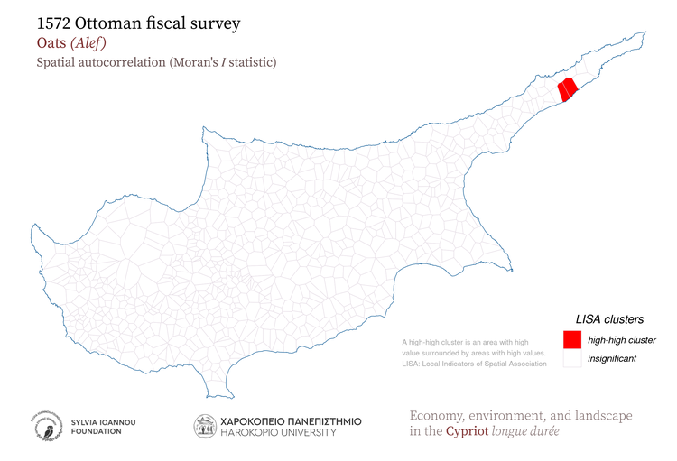
1572, Oats, Spatial autocorrelation (Moran's I statistic)
1572 Ottoman fiscal survey Oats Spatial autocorrelation (Moran's I) A high-high cluster is an area with high value surrounded by areas with high values. LISA: Local Indicators οf Spatial Association Alef kile (keyl) weight Harokopio University Sylvia Ioannou foundation Economy, environment, and landscape in the Cypriot longue durée
1572, Oats, Aggregated in 25 sq.km hexagons
1572 Ottoman fiscal survey Oats Aggregated in 25 Km^2 hexagons Comma in the legend is used as thousands separator Alef kile (keyl) weight Harokopio University Sylvia Ioannou foundation Economy, environment, and landscape in the Cypriot longue durée
1572, Oats, Aggregated in 25 sq.km rectangles
1572 Ottoman fiscal survey Oats Aggregated in 25 Km^2 rectangles Comma in the legend is used as thousands separator Alef kile (keyl) weight Harokopio University Sylvia Ioannou foundation Economy, environment, and landscape in the Cypriot longue durée
1572, Oats, Kernel density
1572 Ottoman fiscal survey Oats Kernel density Shades of red color indicate high density of the mapped variable Alef kile (keyl) weight Harokopio University Sylvia Ioannou foundation Economy, environment, and landscape in the Cypriot longue durée

Lentils

1572, Lentils, Proportional symbols
1572 Ottoman fiscal survey Lentils Proportional symbols Symbol size is relative to the magnitude of each feature attribute. Mercimek kile (keyl) weight Harokopio University Sylvia Ioannou foundation Economy, environment, and landscape in the Cypriot longue durée
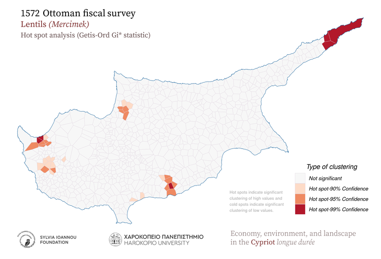
1572, Lentils, Hot spot analysis (Getis-Ord Gi* statistic)
1572 Ottoman fiscal survey Lentils Kernel density Hot spot analysis (Getis-Ord Gi* statistic) Hot spots indicate significant clustering of high values and cold spots indicate significant clustering of low values. Mercimek kile (keyl) weight Harokopio University Sylvia Ioannou foundation Economy, environment, and landscape in the Cypriot longue durée
1572, Lentils, Aggregated in various regions of the island
1572 Ottoman fiscal survey Lentils Aggregated in 1885 subdistricts Subdistricts 1885 (Kitchener's map) Modern districts Height zones Geographic regions Mercimek kile (keyl) weight Harokopio University Sylvia Ioannou foundation Economy, environment, and landscape in the Cypriot longue durée
1572, Lentils, Aggregated in major drainage basins
1572 Ottoman fiscal survey Lentils Aggregated in major drainage basins Mercimek kile (keyl) weight Harokopio University Sylvia Ioannou foundation Economy, environment, and landscape in the Cypriot longue durée
1572, Lentils, Thiessen polygons
1572 Ottoman fiscal survey Lentils Thiessen polygons Gray areas indicate zero values for the variable. Comma in the legend is used as thousands separator Mercimek kile (keyl) weight Harokopio University Sylvia Ioannou foundation Economy, environment, and landscape in the Cypriot longue durée
1572, Lentils, Spatial autocorrelation (Moran's I statistic)
1572 Ottoman fiscal survey Lentils Spatial autocorrelation (Moran's I) A high-high cluster is an area with high value surrounded by areas with high values. LISA: Local Indicators οf Spatial Association Mercimek kile (keyl) weight Harokopio University Sylvia Ioannou foundation Economy, environment, and landscape in the Cypriot longue durée
1572, Lentils, Aggregated in 25 sq.km hexagons
1572 Ottoman fiscal survey Lentils Aggregated in 25 Km^2 hexagons Comma in the legend is used as thousands separator Mercimek kile (keyl) weight Harokopio University Sylvia Ioannou foundation Economy, environment, and landscape in the Cypriot longue durée
1572, Lentils, Aggregated in 25 sq.km rectangles
1572 Ottoman fiscal survey Lentils Aggregated in 25 Km^2 rectangles Comma in the legend is used as thousands separator Mercimek kile (keyl) weight Harokopio University Sylvia Ioannou foundation Economy, environment, and landscape in the Cypriot longue durée
1572, Lentils, Kernel density
1572 Ottoman fiscal survey Lentils Kernel density Shades of red color indicate high density of the mapped variable Mercimek kile (keyl) weight Harokopio University Sylvia Ioannou foundation Economy, environment, and landscape in the Cypriot longue durée

Broad beans

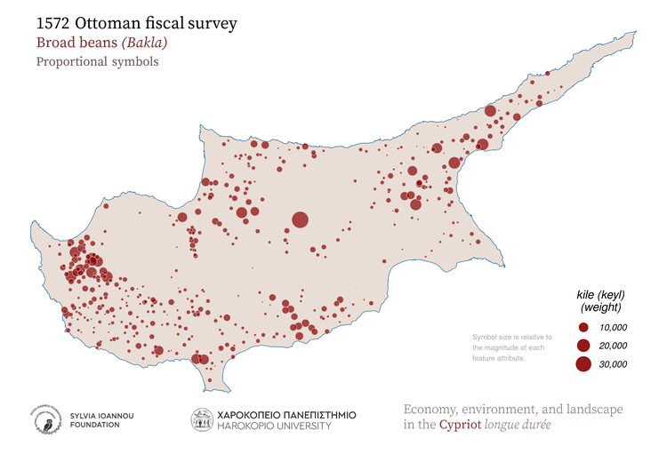
1572, Broad beans, Proportional symbols
1572 Ottoman fiscal survey Broad_beans Proportional symbols Symbol size is relative to the magnitude of each feature attribute. Bakla kile (keyl) weight Harokopio University Sylvia Ioannou foundation Economy, environment, and landscape in the Cypriot longue durée
1572, Broad beans, Hot spot analysis (Getis-Ord Gi* statistic)
1572 Ottoman fiscal survey Broad_beans Kernel density Hot spot analysis (Getis-Ord Gi* statistic) Hot spots indicate significant clustering of high values and cold spots indicate significant clustering of low values. Bakla kile (keyl) weight Harokopio University Sylvia Ioannou foundation Economy, environment, and landscape in the Cypriot longue durée
1572, Broad beans, Aggregated in various regions of the island
1572 Ottoman fiscal survey Broad_beans Aggregated in 1885 subdistricts Subdistricts 1885 (Kitchener's map) Modern districts Height zones Geographic regions Bakla kile (keyl) weight Harokopio University Sylvia Ioannou foundation Economy, environment, and landscape in the Cypriot longue durée
1572, Broad beans, Aggregated in major drainage basins
1572 Ottoman fiscal survey Broad_beans Aggregated in major drainage basins Bakla kile (keyl) weight Harokopio University Sylvia Ioannou foundation Economy, environment, and landscape in the Cypriot longue durée
1572, Broad beans, Thiessen polygons
1572 Ottoman fiscal survey Broad_beans Thiessen polygons Gray areas indicate zero values for the variable. Comma in the legend is used as thousands separator Bakla kile (keyl) weight Harokopio University Sylvia Ioannou foundation Economy, environment, and landscape in the Cypriot longue durée
1572, Broad beans, Spatial autocorrelation (Moran's I statistic)
1572 Ottoman fiscal survey Broad_beans Spatial autocorrelation (Moran's I) A high-high cluster is an area with high value surrounded by areas with high values. LISA: Local Indicators οf Spatial Association Bakla kile (keyl) weight Harokopio University Sylvia Ioannou foundation Economy, environment, and landscape in the Cypriot longue durée
1572, Broad beans, Aggregated in 25 sq.km hexagons
1572 Ottoman fiscal survey Broad_beans Aggregated in 25 Km^2 hexagons Comma in the legend is used as thousands separator Bakla kile (keyl) weight Harokopio University Sylvia Ioannou foundation Economy, environment, and landscape in the Cypriot longue durée
1572, Broad beans, Aggregated in 25 sq.km rectangles
1572 Ottoman fiscal survey Broad_beans Aggregated in 25 Km^2 rectangles Comma in the legend is used as thousands separator Bakla kile (keyl) weight Harokopio University Sylvia Ioannou foundation Economy, environment, and landscape in the Cypriot longue durée
1572, Broad beans, Kernel density
1572 Ottoman fiscal survey Broad_beans Kernel density Shades of red color indicate high density of the mapped variable Bakla kile (keyl) weight Harokopio University Sylvia Ioannou foundation Economy, environment, and landscape in the Cypriot longue durée

Chickpeas

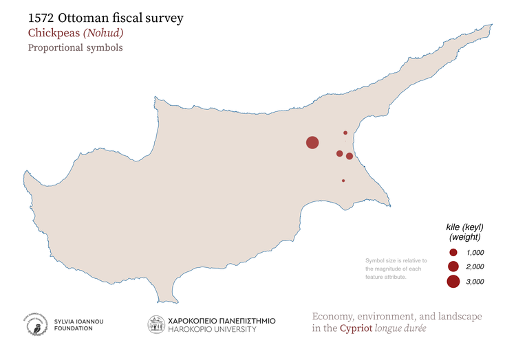
1572, Chickpeas, Proportional symbols
1572 Ottoman fiscal survey Chickpeas Proportional symbols Symbol size is relative to the magnitude of each feature attribute. Nohud kile (keyl) weight Harokopio University Sylvia Ioannou foundation Economy, environment, and landscape in the Cypriot longue durée
1572, Chickpeas, Hot spot analysis (Getis-Ord Gi* statistic)
1572 Ottoman fiscal survey Chickpeas Kernel density Hot spot analysis (Getis-Ord Gi* statistic) Hot spots indicate significant clustering of high values and cold spots indicate significant clustering of low values. Nohud kile (keyl) weight Harokopio University Sylvia Ioannou foundation Economy, environment, and landscape in the Cypriot longue durée
1572, Chickpeas, Aggregated in various regions of the island
1572 Ottoman fiscal survey Chickpeas Aggregated in 1885 subdistricts Subdistricts 1885 (Kitchener's map) Modern districts Height zones Geographic regions Nohud kile (keyl) weight Harokopio University Sylvia Ioannou foundation Economy, environment, and landscape in the Cypriot longue durée
1572, Chickpeas, Aggregated in major drainage basins
1572 Ottoman fiscal survey Chickpeas Aggregated in major drainage basins Nohud kile (keyl) weight Harokopio University Sylvia Ioannou foundation Economy, environment, and landscape in the Cypriot longue durée
1572, Chickpeas, Thiessen polygons
1572 Ottoman fiscal survey Chickpeas Thiessen polygons Gray areas indicate zero values for the variable. Comma in the legend is used as thousands separator Nohud kile (keyl) weight Harokopio University Sylvia Ioannou foundation Economy, environment, and landscape in the Cypriot longue durée
1572, Chickpeas, Spatial autocorrelation (Moran's I statistic)
1572 Ottoman fiscal survey Chickpeas Spatial autocorrelation (Moran's I) A high-high cluster is an area with high value surrounded by areas with high values. LISA: Local Indicators οf Spatial Association Nohud kile (keyl) weight Harokopio University Sylvia Ioannou foundation Economy, environment, and landscape in the Cypriot longue durée
1572, Chickpeas, Aggregated in 25 sq.km hexagons
1572 Ottoman fiscal survey Chickpeas Aggregated in 25 Km^2 hexagons Comma in the legend is used as thousands separator Nohud kile (keyl) weight Harokopio University Sylvia Ioannou foundation Economy, environment, and landscape in the Cypriot longue durée
1572, Chickpeas, Aggregated in 25 sq.km rectangles
1572 Ottoman fiscal survey Chickpeas Aggregated in 25 Km^2 rectangles Comma in the legend is used as thousands separator Nohud kile (keyl) weight Harokopio University Sylvia Ioannou foundation Economy, environment, and landscape in the Cypriot longue durée
1572, Chickpeas, Kernel density
1572 Ottoman fiscal survey Chickpeas Kernel density Shades of red color indicate high density of the mapped variable Nohud kile (keyl) weight Harokopio University Sylvia Ioannou foundation Economy, environment, and landscape in the Cypriot longue durée

Black eyed beans

1572, Black eyed beans, Proportional symbols
1572 Ottoman fiscal survey Black_eyed_beans Proportional symbols Symbol size is relative to the magnitude of each feature attribute. Böğrülce kile (keyl) weight Harokopio University Sylvia Ioannou foundation Economy, environment, and landscape in the Cypriot longue durée
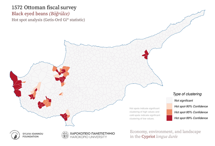
1572, Black eyed beans, Hot spot analysis (Getis-Ord Gi* statistic)
1572 Ottoman fiscal survey Black_eyed_beans Kernel density Hot spot analysis (Getis-Ord Gi* statistic) Hot spots indicate significant clustering of high values and cold spots indicate significant clustering of low values. Böğrülce kile (keyl) weight Harokopio University Sylvia Ioannou foundation Economy, environment, and landscape in the Cypriot longue durée
1572, Black eyed beans, Aggregated in various regions of the island
1572 Ottoman fiscal survey Black_eyed_beans Aggregated in 1885 subdistricts Subdistricts 1885 (Kitchener's map) Modern districts Height zones Geographic regions Böğrülce kile (keyl) weight Harokopio University Sylvia Ioannou foundation Economy, environment, and landscape in the Cypriot longue durée
1572, Black eyed beans, Aggregated in major drainage basins
1572 Ottoman fiscal survey Black_eyed_beans Aggregated in major drainage basins Böğrülce kile (keyl) weight Harokopio University Sylvia Ioannou foundation Economy, environment, and landscape in the Cypriot longue durée
1572, Black eyed beans, Thiessen polygons
1572 Ottoman fiscal survey Black_eyed_beans Thiessen polygons Gray areas indicate zero values for the variable. Comma in the legend is used as thousands separator Böğrülce kile (keyl) weight Harokopio University Sylvia Ioannou foundation Economy, environment, and landscape in the Cypriot longue durée
1572, Black eyed beans, Spatial autocorrelation (Moran's I statistic)
1572 Ottoman fiscal survey Black_eyed_beans Spatial autocorrelation (Moran's I) A high-high cluster is an area with high value surrounded by areas with high values. LISA: Local Indicators οf Spatial Association Böğrülce kile (keyl) weight Harokopio University Sylvia Ioannou foundation Economy, environment, and landscape in the Cypriot longue durée
1572, Black eyed beans, Aggregated in 25 sq.km hexagons
1572 Ottoman fiscal survey Black_eyed_beans Aggregated in 25 Km^2 hexagons Comma in the legend is used as thousands separator Böğrülce kile (keyl) weight Harokopio University Sylvia Ioannou foundation Economy, environment, and landscape in the Cypriot longue durée
1572, Black eyed beans, Aggregated in 25 sq.km rectangles
1572 Ottoman fiscal survey Black_eyed_beans Aggregated in 25 Km^2 rectangles Comma in the legend is used as thousands separator Böğrülce kile (keyl) weight Harokopio University Sylvia Ioannou foundation Economy, environment, and landscape in the Cypriot longue durée
1572, Black eyed beans, Kernel density
1572 Ottoman fiscal survey Black_eyed_beans Kernel density Shades of red color indicate high density of the mapped variable Böğrülce kile (keyl) weight Harokopio University Sylvia Ioannou foundation Economy, environment, and landscape in the Cypriot longue durée

Olives

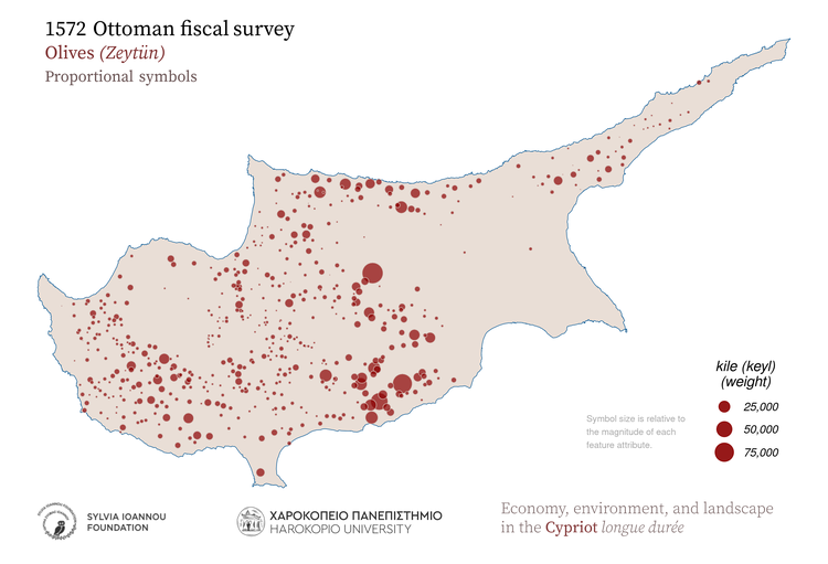
1572, Olives, Proportional symbols
1572 Ottoman fiscal survey Olives Proportional symbols Symbol size is relative to the magnitude of each feature attribute. Zeytün kile (keyl) weight Harokopio University Sylvia Ioannou foundation Economy, environment, and landscape in the Cypriot longue durée
1572, Olives, Hot spot analysis (Getis-Ord Gi* statistic)
1572 Ottoman fiscal survey Olives Kernel density Hot spot analysis (Getis-Ord Gi* statistic) Hot spots indicate significant clustering of high values and cold spots indicate significant clustering of low values. Zeytün kile (keyl) weight Harokopio University Sylvia Ioannou foundation Economy, environment, and landscape in the Cypriot longue durée
1572, Olives, Aggregated in various regions of the island
1572 Ottoman fiscal survey Olives Aggregated in 1885 subdistricts Subdistricts 1885 (Kitchener's map) Modern districts Height zones Geographic regions Zeytün kile (keyl) weight Harokopio University Sylvia Ioannou foundation Economy, environment, and landscape in the Cypriot longue durée
1572, Olives, Aggregated in major drainage basins
1572 Ottoman fiscal survey Olives Aggregated in major drainage basins Zeytün kile (keyl) weight Harokopio University Sylvia Ioannou foundation Economy, environment, and landscape in the Cypriot longue durée
1572, Olives, Thiessen polygons
1572 Ottoman fiscal survey Olives Thiessen polygons Gray areas indicate zero values for the variable. Comma in the legend is used as thousands separator Zeytün kile (keyl) weight Harokopio University Sylvia Ioannou foundation Economy, environment, and landscape in the Cypriot longue durée
1572, Olives, Spatial autocorrelation (Moran's I statistic)
1572 Ottoman fiscal survey Olives Spatial autocorrelation (Moran's I) A high-high cluster is an area with high value surrounded by areas with high values. LISA: Local Indicators οf Spatial Association Zeytün kile (keyl) weight Harokopio University Sylvia Ioannou foundation Economy, environment, and landscape in the Cypriot longue durée
1572, Olives, Aggregated in 25 sq.km hexagons
1572 Ottoman fiscal survey Olives Aggregated in 25 Km^2 hexagons Comma in the legend is used as thousands separator Zeytün kile (keyl) weight Harokopio University Sylvia Ioannou foundation Economy, environment, and landscape in the Cypriot longue durée
1572, Olives, Aggregated in 25 sq.km rectangles
1572 Ottoman fiscal survey Olives Aggregated in 25 Km^2 rectangles Comma in the legend is used as thousands separator Zeytün kile (keyl) weight Harokopio University Sylvia Ioannou foundation Economy, environment, and landscape in the Cypriot longue durée
1572, Olives, Kernel density
1572 Ottoman fiscal survey Olives Kernel density Shades of red color indicate high density of the mapped variable Zeytün kile (keyl) weight Harokopio University Sylvia Ioannou foundation Economy, environment, and landscape in the Cypriot longue durée

Carobs

1572, Carobs, Proportional symbols
1572 Ottoman fiscal survey Carobs Proportional symbols Symbol size is relative to the magnitude of each feature attribute. Harnup kantar weight Harokopio University Sylvia Ioannou foundation Economy, environment, and landscape in the Cypriot longue durée
1572, Carobs, Hot spot analysis (Getis-Ord Gi* statistic)
1572 Ottoman fiscal survey Carobs Kernel density Hot spot analysis (Getis-Ord Gi* statistic) Hot spots indicate significant clustering of high values and cold spots indicate significant clustering of low values. Harnup kantar weight Harokopio University Sylvia Ioannou foundation Economy, environment, and landscape in the Cypriot longue durée
1572, Carobs, Aggregated in various regions of the island
1572 Ottoman fiscal survey Carobs Aggregated in 1885 subdistricts Subdistricts 1885 (Kitchener's map) Modern districts Height zones Geographic regions Harnup kantar weight Harokopio University Sylvia Ioannou foundation Economy, environment, and landscape in the Cypriot longue durée
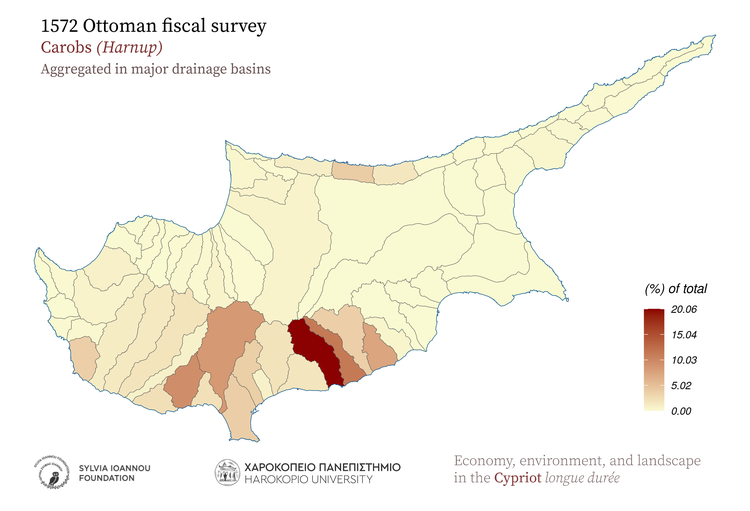
1572, Carobs, Aggregated in major drainage basins
1572 Ottoman fiscal survey Carobs Aggregated in major drainage basins Harnup kantar weight Harokopio University Sylvia Ioannou foundation Economy, environment, and landscape in the Cypriot longue durée
1572, Carobs, Thiessen polygons
1572 Ottoman fiscal survey Carobs Thiessen polygons Gray areas indicate zero values for the variable. Comma in the legend is used as thousands separator Harnup kantar weight Harokopio University Sylvia Ioannou foundation Economy, environment, and landscape in the Cypriot longue durée
1572, Carobs, Spatial autocorrelation (Moran's I statistic)
1572 Ottoman fiscal survey Carobs Spatial autocorrelation (Moran's I) A high-high cluster is an area with high value surrounded by areas with high values. LISA: Local Indicators οf Spatial Association Harnup kantar weight Harokopio University Sylvia Ioannou foundation Economy, environment, and landscape in the Cypriot longue durée
1572, Carobs, Aggregated in 25 sq.km hexagons
1572 Ottoman fiscal survey Carobs Aggregated in 25 Km^2 hexagons Comma in the legend is used as thousands separator Harnup kantar weight Harokopio University Sylvia Ioannou foundation Economy, environment, and landscape in the Cypriot longue durée
1572, Carobs, Aggregated in 25 sq.km rectangles
1572 Ottoman fiscal survey Carobs Aggregated in 25 Km^2 rectangles Comma in the legend is used as thousands separator Harnup kantar weight Harokopio University Sylvia Ioannou foundation Economy, environment, and landscape in the Cypriot longue durée
1572, Carobs, Kernel density
1572 Ottoman fiscal survey Carobs Kernel density Shades of red color indicate high density of the mapped variable Harnup kantar weight Harokopio University Sylvia Ioannou foundation Economy, environment, and landscape in the Cypriot longue durée

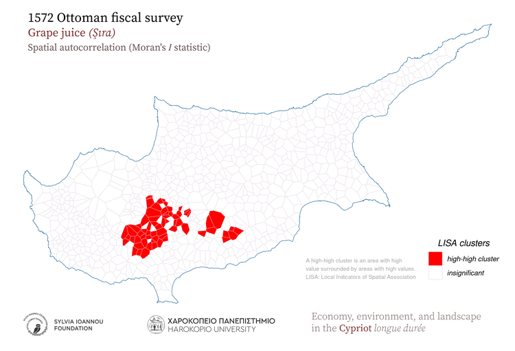
Grape juice

1572, Grape juice, Proportional symbols
1572 Ottoman fiscal survey Grape_juice Proportional symbols Symbol size is relative to the magnitude of each feature attribute. Şıra hıml volume Harokopio University Sylvia Ioannou foundation Economy, environment, and landscape in the Cypriot longue durée
1572, Grape juice, Hot spot analysis (Getis-Ord Gi* statistic)
1572 Ottoman fiscal survey Grape_juice Kernel density Hot spot analysis (Getis-Ord Gi* statistic) Hot spots indicate significant clustering of high values and cold spots indicate significant clustering of low values. Şıra hıml volume Harokopio University Sylvia Ioannou foundation Economy, environment, and landscape in the Cypriot longue durée
1572, Grape juice, Aggregated in various regions of the island
1572 Ottoman fiscal survey Grape_juice Aggregated in 1885 subdistricts Subdistricts 1885 (Kitchener's map) Modern districts Height zones Geographic regions Şıra hıml volume Harokopio University Sylvia Ioannou foundation Economy, environment, and landscape in the Cypriot longue durée
1572, Grape juice, Aggregated in major drainage basins
1572 Ottoman fiscal survey Grape_juice Aggregated in major drainage basins Şıra hıml volume Harokopio University Sylvia Ioannou foundation Economy, environment, and landscape in the Cypriot longue durée
1572, Grape juice, Thiessen polygons
1572 Ottoman fiscal survey Grape_juice Thiessen polygons Gray areas indicate zero values for the variable. Comma in the legend is used as thousands separator Şıra hıml volume Harokopio University Sylvia Ioannou foundation Economy, environment, and landscape in the Cypriot longue durée
1572, Grape juice, Spatial autocorrelation (Moran's I statistic)
1572 Ottoman fiscal survey Grape_juice Spatial autocorrelation (Moran's I) A high-high cluster is an area with high value surrounded by areas with high values. LISA: Local Indicators οf Spatial Association Şıra hıml volume Harokopio University Sylvia Ioannou foundation Economy, environment, and landscape in the Cypriot longue durée
1572, Grape juice, Aggregated in 25 sq.km hexagons
1572 Ottoman fiscal survey Grape_juice Aggregated in 25 Km^2 hexagons Comma in the legend is used as thousands separator Şıra hıml volume Harokopio University Sylvia Ioannou foundation Economy, environment, and landscape in the Cypriot longue durée
1572, Grape juice, Aggregated in 25 sq.km rectangles
1572 Ottoman fiscal survey Grape_juice Aggregated in 25 Km^2 rectangles Comma in the legend is used as thousands separator Şıra hıml volume Harokopio University Sylvia Ioannou foundation Economy, environment, and landscape in the Cypriot longue durée
1572, Grape juice, Kernel density
1572 Ottoman fiscal survey Grape_juice Kernel density Shades of red color indicate high density of the mapped variable Şıra hıml volume Harokopio University Sylvia Ioannou foundation Economy, environment, and landscape in the Cypriot longue durée

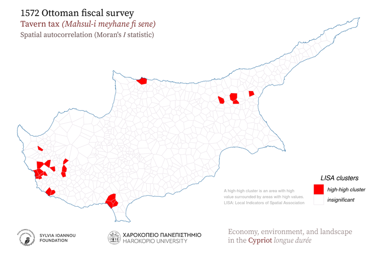
Tavern tax

1572, Tavern tax, Proportional symbols
1572 Ottoman fiscal survey Tavern_tax Proportional symbols Symbol size is relative to the magnitude of each feature attribute. Mahsul-i_meyhane_fi_sene akçe value Harokopio University Sylvia Ioannou foundation Economy, environment, and landscape in the Cypriot longue durée
1572, Tavern tax, Hot spot analysis (Getis-Ord Gi* statistic)
1572 Ottoman fiscal survey Tavern_tax Kernel density Hot spot analysis (Getis-Ord Gi* statistic) Hot spots indicate significant clustering of high values and cold spots indicate significant clustering of low values. Mahsul-i_meyhane_fi_sene akçe value Harokopio University Sylvia Ioannou foundation Economy, environment, and landscape in the Cypriot longue durée
1572, Tavern tax, Aggregated in various regions of the island
1572 Ottoman fiscal survey Tavern_tax Aggregated in 1885 subdistricts Subdistricts 1885 (Kitchener's map) Modern districts Height zones Geographic regions Mahsul-i_meyhane_fi_sene akçe value Harokopio University Sylvia Ioannou foundation Economy, environment, and landscape in the Cypriot longue durée
1572, Tavern tax, Aggregated in major drainage basins
1572 Ottoman fiscal survey Tavern_tax Aggregated in major drainage basins Mahsul-i_meyhane_fi_sene akçe value Harokopio University Sylvia Ioannou foundation Economy, environment, and landscape in the Cypriot longue durée
1572, Tavern tax, Thiessen polygons
1572 Ottoman fiscal survey Tavern_tax Thiessen polygons Gray areas indicate zero values for the variable. Comma in the legend is used as thousands separator Mahsul-i_meyhane_fi_sene akçe value Harokopio University Sylvia Ioannou foundation Economy, environment, and landscape in the Cypriot longue durée
1572, Tavern tax, Spatial autocorrelation (Moran's I statistic)
1572 Ottoman fiscal survey Tavern_tax Spatial autocorrelation (Moran's I) A high-high cluster is an area with high value surrounded by areas with high values. LISA: Local Indicators οf Spatial Association Mahsul-i_meyhane_fi_sene akçe value Harokopio University Sylvia Ioannou foundation Economy, environment, and landscape in the Cypriot longue durée
1572, Tavern tax, Aggregated in 25 sq.km hexagons
1572 Ottoman fiscal survey Tavern_tax Aggregated in 25 Km^2 hexagons Comma in the legend is used as thousands separator Mahsul-i_meyhane_fi_sene akçe value Harokopio University Sylvia Ioannou foundation Economy, environment, and landscape in the Cypriot longue durée
1572, Tavern tax, Aggregated in 25 sq.km rectangles
1572 Ottoman fiscal survey Tavern_tax Aggregated in 25 Km^2 rectangles Comma in the legend is used as thousands separator Mahsul-i_meyhane_fi_sene akçe value Harokopio University Sylvia Ioannou foundation Economy, environment, and landscape in the Cypriot longue durée
1572, Tavern tax, Kernel density
1572 Ottoman fiscal survey Tavern_tax Kernel density Shades of red color indicate high density of the mapped variable Mahsul-i_meyhane_fi_sene akçe value Harokopio University Sylvia Ioannou foundation Economy, environment, and landscape in the Cypriot longue durée

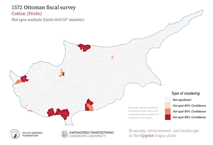
Cotton

1572, Cotton, Proportional symbols
1572 Ottoman fiscal survey Cotton Proportional symbols Symbol size is relative to the magnitude of each feature attribute. Penbe kantar weight Harokopio University Sylvia Ioannou foundation Economy, environment, and landscape in the Cypriot longue durée
1572, Cotton, Hot spot analysis (Getis-Ord Gi* statistic)
1572 Ottoman fiscal survey Cotton Kernel density Hot spot analysis (Getis-Ord Gi* statistic) Hot spots indicate significant clustering of high values and cold spots indicate significant clustering of low values. Penbe kantar weight Harokopio University Sylvia Ioannou foundation Economy, environment, and landscape in the Cypriot longue durée
1572, Cotton, Aggregated in various regions of the island
1572 Ottoman fiscal survey Cotton Aggregated in 1885 subdistricts Subdistricts 1885 (Kitchener's map) Modern districts Height zones Geographic regions Penbe kantar weight Harokopio University Sylvia Ioannou foundation Economy, environment, and landscape in the Cypriot longue durée
1572, Cotton, Aggregated in major drainage basins
1572 Ottoman fiscal survey Cotton Aggregated in major drainage basins Penbe kantar weight Harokopio University Sylvia Ioannou foundation Economy, environment, and landscape in the Cypriot longue durée
1572, Cotton, Thiessen polygons
1572 Ottoman fiscal survey Cotton Thiessen polygons Gray areas indicate zero values for the variable. Comma in the legend is used as thousands separator Penbe kantar weight Harokopio University Sylvia Ioannou foundation Economy, environment, and landscape in the Cypriot longue durée
1572, Cotton, Spatial autocorrelation (Moran's I statistic)
1572 Ottoman fiscal survey Cotton Spatial autocorrelation (Moran's I) A high-high cluster is an area with high value surrounded by areas with high values. LISA: Local Indicators οf Spatial Association Penbe kantar weight Harokopio University Sylvia Ioannou foundation Economy, environment, and landscape in the Cypriot longue durée
1572, Cotton, Aggregated in 25 sq.km hexagons
1572 Ottoman fiscal survey Cotton Aggregated in 25 Km^2 hexagons Comma in the legend is used as thousands separator Penbe kantar weight Harokopio University Sylvia Ioannou foundation Economy, environment, and landscape in the Cypriot longue durée
1572, Cotton, Aggregated in 25 sq.km rectangles
1572 Ottoman fiscal survey Cotton Aggregated in 25 Km^2 rectangles Comma in the legend is used as thousands separator Penbe kantar weight Harokopio University Sylvia Ioannou foundation Economy, environment, and landscape in the Cypriot longue durée
1572, Cotton, Kernel density
1572 Ottoman fiscal survey Cotton Kernel density Shades of red color indicate high density of the mapped variable Penbe kantar weight Harokopio University Sylvia Ioannou foundation Economy, environment, and landscape in the Cypriot longue durée

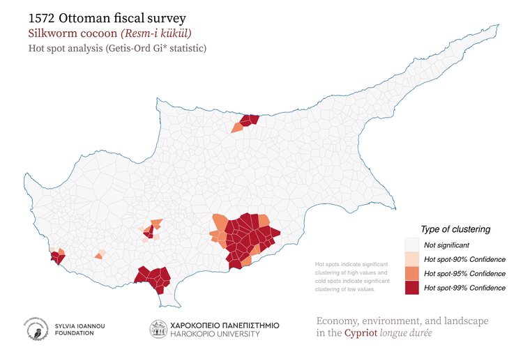
Silkworm cocoon

1572, Silkworm cocoon, Proportional symbols
1572 Ottoman fiscal survey Silkworm_cocoon Proportional symbols Symbol size is relative to the magnitude of each feature attribute. Resm-i_kükül akçe value Harokopio University Sylvia Ioannou foundation Economy, environment, and landscape in the Cypriot longue durée
1572, Silkworm cocoon, Hot spot analysis (Getis-Ord Gi* statistic)
1572 Ottoman fiscal survey Silkworm_cocoon Kernel density Hot spot analysis (Getis-Ord Gi* statistic) Hot spots indicate significant clustering of high values and cold spots indicate significant clustering of low values. Resm-i_kükül akçe value Harokopio University Sylvia Ioannou foundation Economy, environment, and landscape in the Cypriot longue durée
1572, Silkworm cocoon, Aggregated in various regions of the island
1572 Ottoman fiscal survey Silkworm_cocoon Aggregated in 1885 subdistricts Subdistricts 1885 (Kitchener's map) Modern districts Height zones Geographic regions Resm-i_kükül akçe value Harokopio University Sylvia Ioannou foundation Economy, environment, and landscape in the Cypriot longue durée
1572, Silkworm cocoon, Aggregated in major drainage basins
1572 Ottoman fiscal survey Silkworm_cocoon Aggregated in major drainage basins Resm-i_kükül akçe value Harokopio University Sylvia Ioannou foundation Economy, environment, and landscape in the Cypriot longue durée
1572, Silkworm cocoon, Thiessen polygons
1572 Ottoman fiscal survey Silkworm_cocoon Thiessen polygons Gray areas indicate zero values for the variable. Comma in the legend is used as thousands separator Resm-i_kükül akçe value Harokopio University Sylvia Ioannou foundation Economy, environment, and landscape in the Cypriot longue durée
1572, Silkworm cocoon, Spatial autocorrelation (Moran's I statistic)
1572 Ottoman fiscal survey Silkworm_cocoon Spatial autocorrelation (Moran's I) A high-high cluster is an area with high value surrounded by areas with high values. LISA: Local Indicators οf Spatial Association Resm-i_kükül akçe value Harokopio University Sylvia Ioannou foundation Economy, environment, and landscape in the Cypriot longue durée
1572, Silkworm cocoon, Aggregated in 25 sq.km hexagons
1572 Ottoman fiscal survey Silkworm_cocoon Aggregated in 25 Km^2 hexagons Comma in the legend is used as thousands separator Resm-i_kükül akçe value Harokopio University Sylvia Ioannou foundation Economy, environment, and landscape in the Cypriot longue durée
1572, Silkworm cocoon, Aggregated in 25 sq.km rectangles
1572 Ottoman fiscal survey Silkworm_cocoon Aggregated in 25 Km^2 rectangles Comma in the legend is used as thousands separator Resm-i_kükül akçe value Harokopio University Sylvia Ioannou foundation Economy, environment, and landscape in the Cypriot longue durée
1572, Silkworm cocoon, Kernel density
1572 Ottoman fiscal survey Silkworm_cocoon Kernel density Shades of red color indicate high density of the mapped variable Resm-i_kükül akçe value Harokopio University Sylvia Ioannou foundation Economy, environment, and landscape in the Cypriot longue durée

Flax

1572, Flax, Proportional symbols
1572 Ottoman fiscal survey Flax Proportional symbols Symbol size is relative to the magnitude of each feature attribute. Ketan demed bundle Harokopio University Sylvia Ioannou foundation Economy, environment, and landscape in the Cypriot longue durée
1572, Flax, Hot spot analysis (Getis-Ord Gi* statistic)
1572 Ottoman fiscal survey Flax Kernel density Hot spot analysis (Getis-Ord Gi* statistic) Hot spots indicate significant clustering of high values and cold spots indicate significant clustering of low values. Ketan demed bundle Harokopio University Sylvia Ioannou foundation Economy, environment, and landscape in the Cypriot longue durée
1572, Flax, Aggregated in various regions of the island
1572 Ottoman fiscal survey Flax Aggregated in 1885 subdistricts Subdistricts 1885 (Kitchener's map) Modern districts Height zones Geographic regions Ketan demed bundle Harokopio University Sylvia Ioannou foundation Economy, environment, and landscape in the Cypriot longue durée
1572, Flax, Aggregated in major drainage basins
1572 Ottoman fiscal survey Flax Aggregated in major drainage basins Ketan demed bundle Harokopio University Sylvia Ioannou foundation Economy, environment, and landscape in the Cypriot longue durée
1572, Flax, Thiessen polygons
1572 Ottoman fiscal survey Flax Thiessen polygons Gray areas indicate zero values for the variable. Comma in the legend is used as thousands separator Ketan demed bundle Harokopio University Sylvia Ioannou foundation Economy, environment, and landscape in the Cypriot longue durée
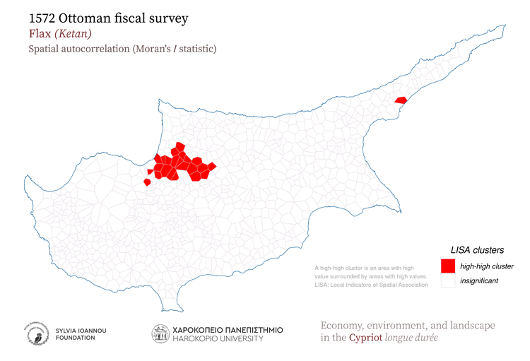
1572, Flax, Spatial autocorrelation (Moran's I statistic)
1572 Ottoman fiscal survey Flax Spatial autocorrelation (Moran's I) A high-high cluster is an area with high value surrounded by areas with high values. LISA: Local Indicators οf Spatial Association Ketan demed bundle Harokopio University Sylvia Ioannou foundation Economy, environment, and landscape in the Cypriot longue durée
1572, Flax, Aggregated in 25 sq.km hexagons
1572 Ottoman fiscal survey Flax Aggregated in 25 Km^2 hexagons Comma in the legend is used as thousands separator Ketan demed bundle Harokopio University Sylvia Ioannou foundation Economy, environment, and landscape in the Cypriot longue durée
1572, Flax, Aggregated in 25 sq.km rectangles
1572 Ottoman fiscal survey Flax Aggregated in 25 Km^2 rectangles Comma in the legend is used as thousands separator Ketan demed bundle Harokopio University Sylvia Ioannou foundation Economy, environment, and landscape in the Cypriot longue durée
1572, Flax, Kernel density
1572 Ottoman fiscal survey Flax Kernel density Shades of red color indicate high density of the mapped variable Ketan demed bundle Harokopio University Sylvia Ioannou foundation Economy, environment, and landscape in the Cypriot longue durée

Hemp

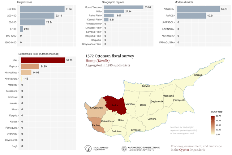
1572, Hemp, Proportional symbols
1572 Ottoman fiscal survey Hemp Proportional symbols Symbol size is relative to the magnitude of each feature attribute. Kendir kantar weight Harokopio University Sylvia Ioannou foundation Economy, environment, and landscape in the Cypriot longue durée
1572, Hemp, Hot spot analysis (Getis-Ord Gi* statistic)
1572 Ottoman fiscal survey Hemp Kernel density Hot spot analysis (Getis-Ord Gi* statistic) Hot spots indicate significant clustering of high values and cold spots indicate significant clustering of low values. Kendir kantar weight Harokopio University Sylvia Ioannou foundation Economy, environment, and landscape in the Cypriot longue durée
1572, Hemp, Aggregated in various regions of the island
1572 Ottoman fiscal survey Hemp Aggregated in 1885 subdistricts Subdistricts 1885 (Kitchener's map) Modern districts Height zones Geographic regions Kendir kantar weight Harokopio University Sylvia Ioannou foundation Economy, environment, and landscape in the Cypriot longue durée
1572, Hemp, Aggregated in major drainage basins
1572 Ottoman fiscal survey Hemp Aggregated in major drainage basins Kendir kantar weight Harokopio University Sylvia Ioannou foundation Economy, environment, and landscape in the Cypriot longue durée
1572, Hemp, Thiessen polygons
1572 Ottoman fiscal survey Hemp Thiessen polygons Gray areas indicate zero values for the variable. Comma in the legend is used as thousands separator Kendir kantar weight Harokopio University Sylvia Ioannou foundation Economy, environment, and landscape in the Cypriot longue durée
1572, Hemp, Spatial autocorrelation (Moran's I statistic)
1572 Ottoman fiscal survey Hemp Spatial autocorrelation (Moran's I) A high-high cluster is an area with high value surrounded by areas with high values. LISA: Local Indicators οf Spatial Association Kendir kantar weight Harokopio University Sylvia Ioannou foundation Economy, environment, and landscape in the Cypriot longue durée
1572, Hemp, Aggregated in 25 sq.km hexagons
1572 Ottoman fiscal survey Hemp Aggregated in 25 Km^2 hexagons Comma in the legend is used as thousands separator Kendir kantar weight Harokopio University Sylvia Ioannou foundation Economy, environment, and landscape in the Cypriot longue durée
1572, Hemp, Aggregated in 25 sq.km rectangles
1572 Ottoman fiscal survey Hemp Aggregated in 25 Km^2 rectangles Comma in the legend is used as thousands separator Kendir kantar weight Harokopio University Sylvia Ioannou foundation Economy, environment, and landscape in the Cypriot longue durée
1572, Hemp, Kernel density
1572 Ottoman fiscal survey Hemp Kernel density Shades of red color indicate high density of the mapped variable Kendir kantar weight Harokopio University Sylvia Ioannou foundation Economy, environment, and landscape in the Cypriot longue durée

Gardens and orchards

1572, Gardens and orchards, Proportional symbols
1572 Ottoman fiscal survey Gardens_and_orchards Proportional symbols Symbol size is relative to the magnitude of each feature attribute. Resm-i bağçe/meyve ve besatin akçe value Harokopio University Sylvia Ioannou foundation Economy, environment, and landscape in the Cypriot longue durée
1572, Gardens and orchards, Hot spot analysis (Getis-Ord Gi* statistic)
1572 Ottoman fiscal survey Gardens_and_orchards Kernel density Hot spot analysis (Getis-Ord Gi* statistic) Hot spots indicate significant clustering of high values and cold spots indicate significant clustering of low values. Resm-i bağçe/meyve ve besatin akçe value Harokopio University Sylvia Ioannou foundation Economy, environment, and landscape in the Cypriot longue durée
1572, Gardens and orchards, Aggregated in various regions of the island
1572 Ottoman fiscal survey Gardens_and_orchards Aggregated in 1885 subdistricts Subdistricts 1885 (Kitchener's map) Modern districts Height zones Geographic regions Resm-i bağçe/meyve ve besatin akçe value Harokopio University Sylvia Ioannou foundation Economy, environment, and landscape in the Cypriot longue durée
1572, Gardens and orchards, Aggregated in major drainage basins
1572 Ottoman fiscal survey Gardens_and_orchards Aggregated in major drainage basins Resm-i bağçe/meyve ve besatin akçe value Harokopio University Sylvia Ioannou foundation Economy, environment, and landscape in the Cypriot longue durée
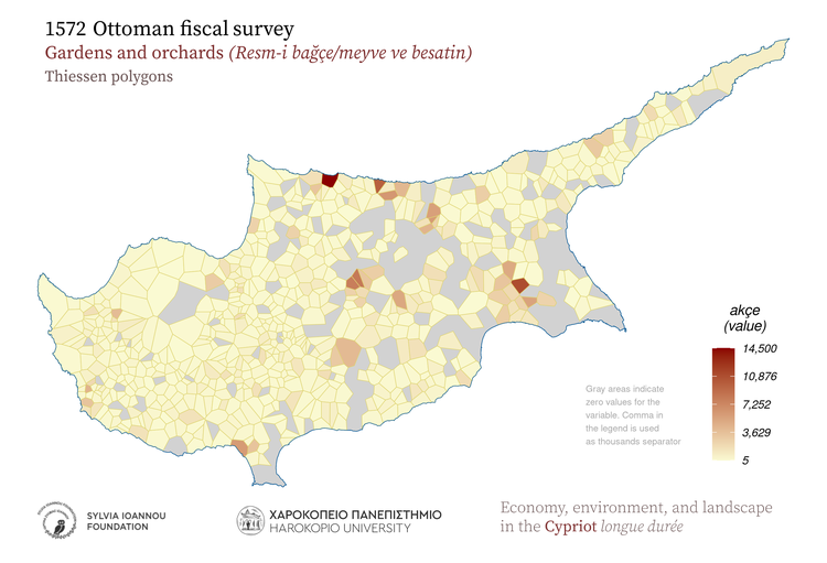
1572, Gardens and orchards, Thiessen polygons
1572 Ottoman fiscal survey Gardens_and_orchards Thiessen polygons Gray areas indicate zero values for the variable. Comma in the legend is used as thousands separator Resm-i bağçe/meyve ve besatin akçe value Harokopio University Sylvia Ioannou foundation Economy, environment, and landscape in the Cypriot longue durée
1572, Gardens and orchards, Spatial autocorrelation (Moran's I statistic)
1572 Ottoman fiscal survey Gardens_and_orchards Spatial autocorrelation (Moran's I) A high-high cluster is an area with high value surrounded by areas with high values. LISA: Local Indicators οf Spatial Association Resm-i bağçe/meyve ve besatin akçe value Harokopio University Sylvia Ioannou foundation Economy, environment, and landscape in the Cypriot longue durée
1572, Gardens and orchards, Aggregated in 25 sq.km hexagons
1572 Ottoman fiscal survey Gardens_and_orchards Aggregated in 25 Km^2 hexagons Comma in the legend is used as thousands separator Resm-i bağçe/meyve ve besatin akçe value Harokopio University Sylvia Ioannou foundation Economy, environment, and landscape in the Cypriot longue durée
1572, Gardens and orchards, Aggregated in 25 sq.km rectangles
1572 Ottoman fiscal survey Gardens_and_orchards Aggregated in 25 Km^2 rectangles Comma in the legend is used as thousands separator Resm-i bağçe/meyve ve besatin akçe value Harokopio University Sylvia Ioannou foundation Economy, environment, and landscape in the Cypriot longue durée
1572, Gardens and orchards, Kernel density
1572 Ottoman fiscal survey Gardens_and_orchards Kernel density Shades of red color indicate high density of the mapped variable Resm-i bağçe/meyve ve besatin akçe value Harokopio University Sylvia Ioannou foundation Economy, environment, and landscape in the Cypriot longue durée

Sheep tax

1572, Sheep tax, Proportional symbols
1572 Ottoman fiscal survey Sheep_tax Proportional symbols Symbol size is relative to the magnitude of each feature attribute. Adet-i_agnam akçe value Harokopio University Sylvia Ioannou foundation Economy, environment, and landscape in the Cypriot longue durée
1572, Sheep tax, Hot spot analysis (Getis-Ord Gi* statistic)
1572 Ottoman fiscal survey Sheep_tax Kernel density Hot spot analysis (Getis-Ord Gi* statistic) Hot spots indicate significant clustering of high values and cold spots indicate significant clustering of low values. Adet-i_agnam akçe value Harokopio University Sylvia Ioannou foundation Economy, environment, and landscape in the Cypriot longue durée
1572, Sheep tax, Aggregated in various regions of the island
1572 Ottoman fiscal survey Sheep_tax Aggregated in 1885 subdistricts Subdistricts 1885 (Kitchener's map) Modern districts Height zones Geographic regions Adet-i_agnam akçe value Harokopio University Sylvia Ioannou foundation Economy, environment, and landscape in the Cypriot longue durée
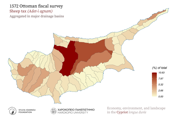
1572, Sheep tax, Aggregated in major drainage basins
1572 Ottoman fiscal survey Sheep_tax Aggregated in major drainage basins Adet-i_agnam akçe value Harokopio University Sylvia Ioannou foundation Economy, environment, and landscape in the Cypriot longue durée
1572, Sheep tax, Thiessen polygons
1572 Ottoman fiscal survey Sheep_tax Thiessen polygons Gray areas indicate zero values for the variable. Comma in the legend is used as thousands separator Adet-i_agnam akçe value Harokopio University Sylvia Ioannou foundation Economy, environment, and landscape in the Cypriot longue durée
1572, Sheep tax, Spatial autocorrelation (Moran's I statistic)
1572 Ottoman fiscal survey Sheep_tax Spatial autocorrelation (Moran's I) A high-high cluster is an area with high value surrounded by areas with high values. LISA: Local Indicators οf Spatial Association Adet-i_agnam akçe value Harokopio University Sylvia Ioannou foundation Economy, environment, and landscape in the Cypriot longue durée
1572, Sheep tax, Aggregated in 25 sq.km hexagons
1572 Ottoman fiscal survey Sheep_tax Aggregated in 25 Km^2 hexagons Comma in the legend is used as thousands separator Adet-i_agnam akçe value Harokopio University Sylvia Ioannou foundation Economy, environment, and landscape in the Cypriot longue durée
1572, Sheep tax, Aggregated in 25 sq.km rectangles
1572 Ottoman fiscal survey Sheep_tax Aggregated in 25 Km^2 rectangles Comma in the legend is used as thousands separator Adet-i_agnam akçe value Harokopio University Sylvia Ioannou foundation Economy, environment, and landscape in the Cypriot longue durée
1572, Sheep tax, Kernel density
1572 Ottoman fiscal survey Sheep_tax Kernel density Shades of red color indicate high density of the mapped variable Adet-i_agnam akçe value Harokopio University Sylvia Ioannou foundation Economy, environment, and landscape in the Cypriot longue durée

Pigs tax

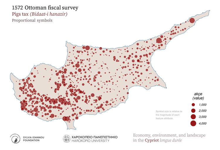
1572, Pigs tax, Proportional symbols
1572 Ottoman fiscal survey Pigs_tax Proportional symbols Symbol size is relative to the magnitude of each feature attribute. Bidaat-i_hanazir akçe value Harokopio University Sylvia Ioannou foundation Economy, environment, and landscape in the Cypriot longue durée
1572, Pigs tax, Hot spot analysis (Getis-Ord Gi* statistic)
1572 Ottoman fiscal survey Pigs_tax Kernel density Hot spot analysis (Getis-Ord Gi* statistic) Hot spots indicate significant clustering of high values and cold spots indicate significant clustering of low values. Bidaat-i_hanazir akçe value Harokopio University Sylvia Ioannou foundation Economy, environment, and landscape in the Cypriot longue durée
1572, Pigs tax, Aggregated in various regions of the island
1572 Ottoman fiscal survey Pigs_tax Aggregated in 1885 subdistricts Subdistricts 1885 (Kitchener's map) Modern districts Height zones Geographic regions Bidaat-i_hanazir akçe value Harokopio University Sylvia Ioannou foundation Economy, environment, and landscape in the Cypriot longue durée
1572, Pigs tax, Aggregated in major drainage basins
1572 Ottoman fiscal survey Pigs_tax Aggregated in major drainage basins Bidaat-i_hanazir akçe value Harokopio University Sylvia Ioannou foundation Economy, environment, and landscape in the Cypriot longue durée
1572, Pigs tax, Thiessen polygons
1572 Ottoman fiscal survey Pigs_tax Thiessen polygons Gray areas indicate zero values for the variable. Comma in the legend is used as thousands separator Bidaat-i_hanazir akçe value Harokopio University Sylvia Ioannou foundation Economy, environment, and landscape in the Cypriot longue durée
1572, Pigs tax, Spatial autocorrelation (Moran's I statistic)
1572 Ottoman fiscal survey Pigs_tax Spatial autocorrelation (Moran's I) A high-high cluster is an area with high value surrounded by areas with high values. LISA: Local Indicators οf Spatial Association Bidaat-i_hanazir akçe value Harokopio University Sylvia Ioannou foundation Economy, environment, and landscape in the Cypriot longue durée
1572, Pigs tax, Aggregated in 25 sq.km hexagons
1572 Ottoman fiscal survey Pigs_tax Aggregated in 25 Km^2 hexagons Comma in the legend is used as thousands separator Bidaat-i_hanazir akçe value Harokopio University Sylvia Ioannou foundation Economy, environment, and landscape in the Cypriot longue durée
1572, Pigs tax, Aggregated in 25 sq.km rectangles
1572 Ottoman fiscal survey Pigs_tax Aggregated in 25 Km^2 rectangles Comma in the legend is used as thousands separator Bidaat-i_hanazir akçe value Harokopio University Sylvia Ioannou foundation Economy, environment, and landscape in the Cypriot longue durée
1572, Pigs tax, Kernel density
1572 Ottoman fiscal survey Pigs_tax Kernel density Shades of red color indicate high density of the mapped variable Bidaat-i_hanazir akçe value Harokopio University Sylvia Ioannou foundation Economy, environment, and landscape in the Cypriot longue durée

Stray animals duty

1572, Stray animals duty, Proportional symbols
1572 Ottoman fiscal survey Stray_animals_duty Proportional symbols Symbol size is relative to the magnitude of each feature attribute. Adet-i_deştbani akçe value Harokopio University Sylvia Ioannou foundation Economy, environment, and landscape in the Cypriot longue durée
1572, Stray animals duty, Hot spot analysis (Getis-Ord Gi* statistic)
1572 Ottoman fiscal survey Stray_animals_duty Kernel density Hot spot analysis (Getis-Ord Gi* statistic) Hot spots indicate significant clustering of high values and cold spots indicate significant clustering of low values. Adet-i_deştbani akçe value Harokopio University Sylvia Ioannou foundation Economy, environment, and landscape in the Cypriot longue durée
1572, Stray animals duty, Aggregated in various regions of the island
1572 Ottoman fiscal survey Stray_animals_duty Aggregated in 1885 subdistricts Subdistricts 1885 (Kitchener's map) Modern districts Height zones Geographic regions Adet-i_deştbani akçe value Harokopio University Sylvia Ioannou foundation Economy, environment, and landscape in the Cypriot longue durée
1572, Stray animals duty, Aggregated in major drainage basins
1572 Ottoman fiscal survey Stray_animals_duty Aggregated in major drainage basins Adet-i_deştbani akçe value Harokopio University Sylvia Ioannou foundation Economy, environment, and landscape in the Cypriot longue durée
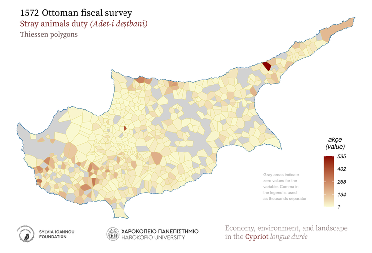
1572, Stray animals duty, Thiessen polygons
1572 Ottoman fiscal survey Stray_animals_duty Thiessen polygons Gray areas indicate zero values for the variable. Comma in the legend is used as thousands separator Adet-i_deştbani akçe value Harokopio University Sylvia Ioannou foundation Economy, environment, and landscape in the Cypriot longue durée
1572, Stray animals duty, Spatial autocorrelation (Moran's I statistic)
1572 Ottoman fiscal survey Stray_animals_duty Spatial autocorrelation (Moran's I) A high-high cluster is an area with high value surrounded by areas with high values. LISA: Local Indicators οf Spatial Association Adet-i_deştbani akçe value Harokopio University Sylvia Ioannou foundation Economy, environment, and landscape in the Cypriot longue durée
1572, Stray animals duty, Aggregated in 25 sq.km hexagons
1572 Ottoman fiscal survey Stray_animals_duty Aggregated in 25 Km^2 hexagons Comma in the legend is used as thousands separator Adet-i_deştbani akçe value Harokopio University Sylvia Ioannou foundation Economy, environment, and landscape in the Cypriot longue durée
1572, Stray animals duty, Aggregated in 25 sq.km rectangles
1572 Ottoman fiscal survey Stray_animals_duty Aggregated in 25 Km^2 rectangles Comma in the legend is used as thousands separator Adet-i_deştbani akçe value Harokopio University Sylvia Ioannou foundation Economy, environment, and landscape in the Cypriot longue durée
1572, Stray animals duty, Kernel density
1572 Ottoman fiscal survey Stray_animals_duty Kernel density Shades of red color indicate high density of the mapped variable Adet-i_deştbani akçe value Harokopio University Sylvia Ioannou foundation Economy, environment, and landscape in the Cypriot longue durée

Sesame

1572, Sesame, Proportional symbols
1572 Ottoman fiscal survey Sesame Proportional symbols Symbol size is relative to the magnitude of each feature attribute. Simsim kile (keyl) weight Harokopio University Sylvia Ioannou foundation Economy, environment, and landscape in the Cypriot longue durée
1572, Sesame, Hot spot analysis (Getis-Ord Gi* statistic)
1572 Ottoman fiscal survey Sesame Kernel density Hot spot analysis (Getis-Ord Gi* statistic) Hot spots indicate significant clustering of high values and cold spots indicate significant clustering of low values. Simsim kile (keyl) weight Harokopio University Sylvia Ioannou foundation Economy, environment, and landscape in the Cypriot longue durée
1572, Sesame, Aggregated in various regions of the island
1572 Ottoman fiscal survey Sesame Aggregated in 1885 subdistricts Subdistricts 1885 (Kitchener's map) Modern districts Height zones Geographic regions Simsim kile (keyl) weight Harokopio University Sylvia Ioannou foundation Economy, environment, and landscape in the Cypriot longue durée
1572, Sesame, Aggregated in major drainage basins
1572 Ottoman fiscal survey Sesame Aggregated in major drainage basins Simsim kile (keyl) weight Harokopio University Sylvia Ioannou foundation Economy, environment, and landscape in the Cypriot longue durée
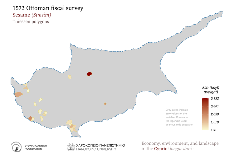
1572, Sesame, Thiessen polygons
1572 Ottoman fiscal survey Sesame Thiessen polygons Gray areas indicate zero values for the variable. Comma in the legend is used as thousands separator Simsim kile (keyl) weight Harokopio University Sylvia Ioannou foundation Economy, environment, and landscape in the Cypriot longue durée
1572, Sesame, Spatial autocorrelation (Moran's I statistic)
1572 Ottoman fiscal survey Sesame Spatial autocorrelation (Moran's I) A high-high cluster is an area with high value surrounded by areas with high values. LISA: Local Indicators οf Spatial Association Simsim kile (keyl) weight Harokopio University Sylvia Ioannou foundation Economy, environment, and landscape in the Cypriot longue durée
1572, Sesame, Aggregated in 25 sq.km hexagons
1572 Ottoman fiscal survey Sesame Aggregated in 25 Km^2 hexagons Comma in the legend is used as thousands separator Simsim kile (keyl) weight Harokopio University Sylvia Ioannou foundation Economy, environment, and landscape in the Cypriot longue durée
1572, Sesame, Aggregated in 25 sq.km rectangles
1572 Ottoman fiscal survey Sesame Aggregated in 25 Km^2 rectangles Comma in the legend is used as thousands separator Simsim kile (keyl) weight Harokopio University Sylvia Ioannou foundation Economy, environment, and landscape in the Cypriot longue durée
1572, Sesame, Kernel density
1572 Ottoman fiscal survey Sesame Kernel density Shades of red color indicate high density of the mapped variable Simsim kile (keyl) weight Harokopio University Sylvia Ioannou foundation Economy, environment, and landscape in the Cypriot longue durée

Saffron

1572, Saffron, Proportional symbols
1572 Ottoman fiscal survey Saffron Proportional symbols Symbol size is relative to the magnitude of each feature attribute. Zafran kile (keyl) weight Harokopio University Sylvia Ioannou foundation Economy, environment, and landscape in the Cypriot longue durée
1572, Saffron, Hot spot analysis (Getis-Ord Gi* statistic)
1572 Ottoman fiscal survey Saffron Kernel density Hot spot analysis (Getis-Ord Gi* statistic) Hot spots indicate significant clustering of high values and cold spots indicate significant clustering of low values. Zafran kile (keyl) weight Harokopio University Sylvia Ioannou foundation Economy, environment, and landscape in the Cypriot longue durée
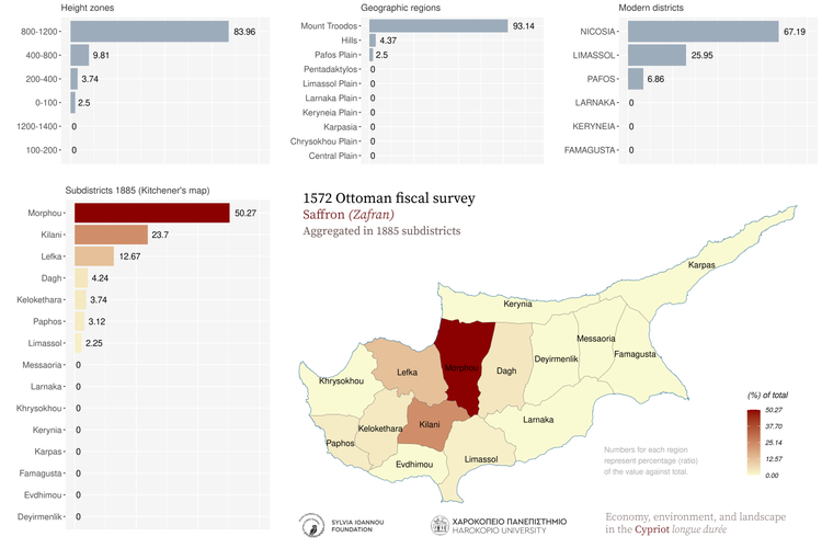
1572, Saffron, Aggregated in various regions of the island
1572 Ottoman fiscal survey Saffron Aggregated in 1885 subdistricts Subdistricts 1885 (Kitchener's map) Modern districts Height zones Geographic regions Zafran kile (keyl) weight Harokopio University Sylvia Ioannou foundation Economy, environment, and landscape in the Cypriot longue durée
1572, Saffron, Aggregated in major drainage basins
1572 Ottoman fiscal survey Saffron Aggregated in major drainage basins Zafran kile (keyl) weight Harokopio University Sylvia Ioannou foundation Economy, environment, and landscape in the Cypriot longue durée
1572, Saffron, Thiessen polygons
1572 Ottoman fiscal survey Saffron Thiessen polygons Gray areas indicate zero values for the variable. Comma in the legend is used as thousands separator Zafran kile (keyl) weight Harokopio University Sylvia Ioannou foundation Economy, environment, and landscape in the Cypriot longue durée
1572, Saffron, Spatial autocorrelation (Moran's I statistic)
1572 Ottoman fiscal survey Saffron Spatial autocorrelation (Moran's I) A high-high cluster is an area with high value surrounded by areas with high values. LISA: Local Indicators οf Spatial Association Zafran kile (keyl) weight Harokopio University Sylvia Ioannou foundation Economy, environment, and landscape in the Cypriot longue durée
1572, Saffron, Aggregated in 25 sq.km hexagons
1572 Ottoman fiscal survey Saffron Aggregated in 25 Km^2 hexagons Comma in the legend is used as thousands separator Zafran kile (keyl) weight Harokopio University Sylvia Ioannou foundation Economy, environment, and landscape in the Cypriot longue durée
1572, Saffron, Aggregated in 25 sq.km rectangles
1572 Ottoman fiscal survey Saffron Aggregated in 25 Km^2 rectangles Comma in the legend is used as thousands separator Zafran kile (keyl) weight Harokopio University Sylvia Ioannou foundation Economy, environment, and landscape in the Cypriot longue durée
1572, Saffron, Kernel density
1572 Ottoman fiscal survey Saffron Kernel density Shades of red color indicate high density of the mapped variable Zafran kile (keyl) weight Harokopio University Sylvia Ioannou foundation Economy, environment, and landscape in the Cypriot longue durée

Walnuts

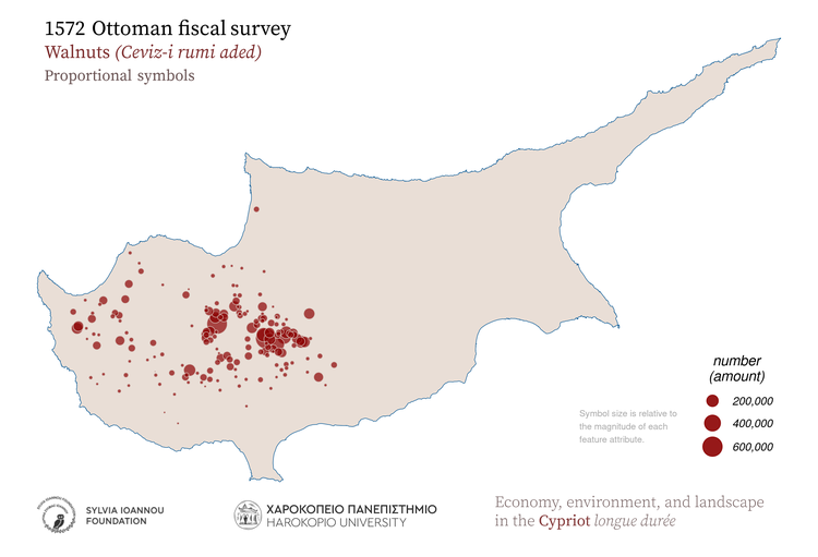
1572, Walnuts, Proportional symbols
1572 Ottoman fiscal survey Walnuts Proportional symbols Symbol size is relative to the magnitude of each feature attribute. Ceviz-i_rumi_aded number amount Harokopio University Sylvia Ioannou foundation Economy, environment, and landscape in the Cypriot longue durée
1572, Walnuts, Hot spot analysis (Getis-Ord Gi* statistic)
1572 Ottoman fiscal survey Walnuts Kernel density Hot spot analysis (Getis-Ord Gi* statistic) Hot spots indicate significant clustering of high values and cold spots indicate significant clustering of low values. Ceviz-i_rumi_aded number amount Harokopio University Sylvia Ioannou foundation Economy, environment, and landscape in the Cypriot longue durée
1572, Walnuts, Aggregated in various regions of the island
1572 Ottoman fiscal survey Walnuts Aggregated in 1885 subdistricts Subdistricts 1885 (Kitchener's map) Modern districts Height zones Geographic regions Ceviz-i_rumi_aded number amount Harokopio University Sylvia Ioannou foundation Economy, environment, and landscape in the Cypriot longue durée
1572, Walnuts, Aggregated in major drainage basins
1572 Ottoman fiscal survey Walnuts Aggregated in major drainage basins Ceviz-i_rumi_aded number amount Harokopio University Sylvia Ioannou foundation Economy, environment, and landscape in the Cypriot longue durée
1572, Walnuts, Thiessen polygons
1572 Ottoman fiscal survey Walnuts Thiessen polygons Gray areas indicate zero values for the variable. Comma in the legend is used as thousands separator Ceviz-i_rumi_aded number amount Harokopio University Sylvia Ioannou foundation Economy, environment, and landscape in the Cypriot longue durée
1572, Walnuts, Spatial autocorrelation (Moran's I statistic)
1572 Ottoman fiscal survey Walnuts Spatial autocorrelation (Moran's I) A high-high cluster is an area with high value surrounded by areas with high values. LISA: Local Indicators οf Spatial Association Ceviz-i_rumi_aded number amount Harokopio University Sylvia Ioannou foundation Economy, environment, and landscape in the Cypriot longue durée
1572, Walnuts, Aggregated in 25 sq.km hexagons
1572 Ottoman fiscal survey Walnuts Aggregated in 25 Km^2 hexagons Comma in the legend is used as thousands separator Ceviz-i_rumi_aded number amount Harokopio University Sylvia Ioannou foundation Economy, environment, and landscape in the Cypriot longue durée
1572, Walnuts, Aggregated in 25 sq.km rectangles
1572 Ottoman fiscal survey Walnuts Aggregated in 25 Km^2 rectangles Comma in the legend is used as thousands separator Ceviz-i_rumi_aded number amount Harokopio University Sylvia Ioannou foundation Economy, environment, and landscape in the Cypriot longue durée
1572, Walnuts, Kernel density
1572 Ottoman fiscal survey Walnuts Kernel density Shades of red color indicate high density of the mapped variable Ceviz-i_rumi_aded number amount Harokopio University Sylvia Ioannou foundation Economy, environment, and landscape in the Cypriot longue durée

Acorns

1572, Acorns, Proportional symbols
1572 Ottoman fiscal survey Acorns Proportional symbols Symbol size is relative to the magnitude of each feature attribute. Resm-i_bellut kile (keyl) weight Harokopio University Sylvia Ioannou foundation Economy, environment, and landscape in the Cypriot longue durée
1572, Acorns, Hot spot analysis (Getis-Ord Gi* statistic)
1572 Ottoman fiscal survey Acorns Kernel density Hot spot analysis (Getis-Ord Gi* statistic) Hot spots indicate significant clustering of high values and cold spots indicate significant clustering of low values. Resm-i_bellut kile (keyl) weight Harokopio University Sylvia Ioannou foundation Economy, environment, and landscape in the Cypriot longue durée
1572, Acorns, Aggregated in various regions of the island
1572 Ottoman fiscal survey Acorns Aggregated in 1885 subdistricts Subdistricts 1885 (Kitchener's map) Modern districts Height zones Geographic regions Resm-i_bellut kile (keyl) weight Harokopio University Sylvia Ioannou foundation Economy, environment, and landscape in the Cypriot longue durée
1572, Acorns, Aggregated in major drainage basins
1572 Ottoman fiscal survey Acorns Aggregated in major drainage basins Resm-i_bellut kile (keyl) weight Harokopio University Sylvia Ioannou foundation Economy, environment, and landscape in the Cypriot longue durée
1572, Acorns, Thiessen polygons
1572 Ottoman fiscal survey Acorns Thiessen polygons Gray areas indicate zero values for the variable. Comma in the legend is used as thousands separator Resm-i_bellut kile (keyl) weight Harokopio University Sylvia Ioannou foundation Economy, environment, and landscape in the Cypriot longue durée
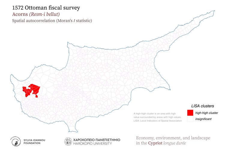
1572, Acorns, Spatial autocorrelation (Moran's I statistic)
1572 Ottoman fiscal survey Acorns Spatial autocorrelation (Moran's I) A high-high cluster is an area with high value surrounded by areas with high values. LISA: Local Indicators οf Spatial Association Resm-i_bellut kile (keyl) weight Harokopio University Sylvia Ioannou foundation Economy, environment, and landscape in the Cypriot longue durée
1572, Acorns, Aggregated in 25 sq.km hexagons
1572 Ottoman fiscal survey Acorns Aggregated in 25 Km^2 hexagons Comma in the legend is used as thousands separator Resm-i_bellut kile (keyl) weight Harokopio University Sylvia Ioannou foundation Economy, environment, and landscape in the Cypriot longue durée
1572, Acorns, Aggregated in 25 sq.km rectangles
1572 Ottoman fiscal survey Acorns Aggregated in 25 Km^2 rectangles Comma in the legend is used as thousands separator Resm-i_bellut kile (keyl) weight Harokopio University Sylvia Ioannou foundation Economy, environment, and landscape in the Cypriot longue durée
1572, Acorns, Kernel density
1572 Ottoman fiscal survey Acorns Kernel density Shades of red color indicate high density of the mapped variable Resm-i_bellut kile (keyl) weight Harokopio University Sylvia Ioannou foundation Economy, environment, and landscape in the Cypriot longue durée

Beehives

1572, Beehives, Proportional symbols
1572 Ottoman fiscal survey Bee_hives Proportional symbols Symbol size is relative to the magnitude of each feature attribute. Resm-i_gevare akçe value Harokopio University Sylvia Ioannou foundation Economy, environment, and landscape in the Cypriot longue durée
1572, Beehives, Hot spot analysis (Getis-Ord Gi* statistic)
1572 Ottoman fiscal survey Bee_hives Kernel density Hot spot analysis (Getis-Ord Gi* statistic) Hot spots indicate significant clustering of high values and cold spots indicate significant clustering of low values. Resm-i_gevare akçe value Harokopio University Sylvia Ioannou foundation Economy, environment, and landscape in the Cypriot longue durée
1572, Beehives, Aggregated in various regions of the island
1572 Ottoman fiscal survey Bee_hives Aggregated in 1885 subdistricts Subdistricts 1885 (Kitchener's map) Modern districts Height zones Geographic regions Resm-i_gevare akçe value Harokopio University Sylvia Ioannou foundation Economy, environment, and landscape in the Cypriot longue durée
1572, Beehives, Aggregated in major drainage basins
1572 Ottoman fiscal survey Bee_hives Aggregated in major drainage basins Resm-i_gevare akçe value Harokopio University Sylvia Ioannou foundation Economy, environment, and landscape in the Cypriot longue durée
1572, Beehives, Thiessen polygons
1572 Ottoman fiscal survey Bee_hives Thiessen polygons Gray areas indicate zero values for the variable. Comma in the legend is used as thousands separator Resm-i_gevare akçe value Harokopio University Sylvia Ioannou foundation Economy, environment, and landscape in the Cypriot longue durée
1572, Beehives, Spatial autocorrelation (Moran's I statistic)
1572 Ottoman fiscal survey Bee_hives Spatial autocorrelation (Moran's I) A high-high cluster is an area with high value surrounded by areas with high values. LISA: Local Indicators οf Spatial Association Resm-i_gevare akçe value Harokopio University Sylvia Ioannou foundation Economy, environment, and landscape in the Cypriot longue durée
1572, Beehives, Aggregated in 25 sq.km hexagons
1572 Ottoman fiscal survey Bee_hives Aggregated in 25 Km^2 hexagons Comma in the legend is used as thousands separator Resm-i_gevare akçe value Harokopio University Sylvia Ioannou foundation Economy, environment, and landscape in the Cypriot longue durée
1572, Beehives, Aggregated in 25 sq.km rectangles
1572 Ottoman fiscal survey Bee_hives Aggregated in 25 Km^2 rectangles Comma in the legend is used as thousands separator Resm-i_gevare akçe value Harokopio University Sylvia Ioannou foundation Economy, environment, and landscape in the Cypriot longue durée
1572, Beehives, Kernel density
1572 Ottoman fiscal survey Bee_hives Kernel density Shades of red color indicate high density of the mapped variable Resm-i_gevare akçe value Harokopio University Sylvia Ioannou foundation Economy, environment, and landscape in the Cypriot longue durée

Watermills

1572, Watermills, Proportional symbols
1572 Ottoman fiscal survey Watermills Proportional symbols Symbol size is relative to the magnitude of each feature attribute. Asyabha number amount Harokopio University Sylvia Ioannou foundation Economy, environment, and landscape in the Cypriot longue durée
1572, Watermills, Hot spot analysis (Getis-Ord Gi* statistic)
1572 Ottoman fiscal survey Watermills Kernel density Hot spot analysis (Getis-Ord Gi* statistic) Hot spots indicate significant clustering of high values and cold spots indicate significant clustering of low values. Asyabha number amount Harokopio University Sylvia Ioannou foundation Economy, environment, and landscape in the Cypriot longue durée
1572, Watermills, Aggregated in various regions of the island
1572 Ottoman fiscal survey Watermills Aggregated in 1885 subdistricts Subdistricts 1885 (Kitchener's map) Modern districts Height zones Geographic regions Asyabha number amount Harokopio University Sylvia Ioannou foundation Economy, environment, and landscape in the Cypriot longue durée
1572, Watermills, Aggregated in major drainage basins
1572 Ottoman fiscal survey Watermills Aggregated in major drainage basins Asyabha number amount Harokopio University Sylvia Ioannou foundation Economy, environment, and landscape in the Cypriot longue durée
1572, Watermills, Thiessen polygons
1572 Ottoman fiscal survey Watermills Thiessen polygons Gray areas indicate zero values for the variable. Comma in the legend is used as thousands separator Asyabha number amount Harokopio University Sylvia Ioannou foundation Economy, environment, and landscape in the Cypriot longue durée
1572, Watermills, Spatial autocorrelation (Moran's I statistic)
1572 Ottoman fiscal survey Watermills Spatial autocorrelation (Moran's I) A high-high cluster is an area with high value surrounded by areas with high values. LISA: Local Indicators οf Spatial Association Asyabha number amount Harokopio University Sylvia Ioannou foundation Economy, environment, and landscape in the Cypriot longue durée
1572, Watermills, Aggregated in 25 sq.km hexagons
1572 Ottoman fiscal survey Watermills Aggregated in 25 Km^2 hexagons Comma in the legend is used as thousands separator Asyabha number amount Harokopio University Sylvia Ioannou foundation Economy, environment, and landscape in the Cypriot longue durée
1572, Watermills, Aggregated in 25 sq.km rectangles
1572 Ottoman fiscal survey Watermills Aggregated in 25 Km^2 rectangles Comma in the legend is used as thousands separator Asyabha number amount Harokopio University Sylvia Ioannou foundation Economy, environment, and landscape in the Cypriot longue durée
1572, Watermills, Kernel density
1572 Ottoman fiscal survey Watermills Kernel density Shades of red color indicate high density of the mapped variable Asyabha number amount Harokopio University Sylvia Ioannou foundation Economy, environment, and landscape in the Cypriot longue durée

Windmills

1572, Windmills, Proportional symbols
1572 Ottoman fiscal survey Windmills Proportional symbols Symbol size is relative to the magnitude of each feature attribute. Asyab-i_yel bab amount Harokopio University Sylvia Ioannou foundation Economy, environment, and landscape in the Cypriot longue durée
1572, Windmills, Hot spot analysis (Getis-Ord Gi* statistic)
1572 Ottoman fiscal survey Windmills Kernel density Hot spot analysis (Getis-Ord Gi* statistic) Hot spots indicate significant clustering of high values and cold spots indicate significant clustering of low values. Asyab-i_yel bab amount Harokopio University Sylvia Ioannou foundation Economy, environment, and landscape in the Cypriot longue durée
1572, Windmills, Aggregated in various regions of the island
1572 Ottoman fiscal survey Windmills Aggregated in 1885 subdistricts Subdistricts 1885 (Kitchener's map) Modern districts Height zones Geographic regions Asyab-i_yel bab amount Harokopio University Sylvia Ioannou foundation Economy, environment, and landscape in the Cypriot longue durée
1572, Windmills, Aggregated in major drainage basins
1572 Ottoman fiscal survey Windmills Aggregated in major drainage basins Asyab-i_yel bab amount Harokopio University Sylvia Ioannou foundation Economy, environment, and landscape in the Cypriot longue durée
1572, Windmills, Thiessen polygons
1572 Ottoman fiscal survey Windmills Thiessen polygons Gray areas indicate zero values for the variable. Comma in the legend is used as thousands separator Asyab-i_yel bab amount Harokopio University Sylvia Ioannou foundation Economy, environment, and landscape in the Cypriot longue durée
1572, Windmills, Spatial autocorrelation (Moran's I statistic)
1572 Ottoman fiscal survey Windmills Spatial autocorrelation (Moran's I) A high-high cluster is an area with high value surrounded by areas with high values. LISA: Local Indicators οf Spatial Association Asyab-i_yel bab amount Harokopio University Sylvia Ioannou foundation Economy, environment, and landscape in the Cypriot longue durée
1572, Windmills, Aggregated in 25 sq.km hexagons
1572 Ottoman fiscal survey Windmills Aggregated in 25 Km^2 hexagons Comma in the legend is used as thousands separator Asyab-i_yel bab amount Harokopio University Sylvia Ioannou foundation Economy, environment, and landscape in the Cypriot longue durée
1572, Windmills, Aggregated in 25 sq.km rectangles
1572 Ottoman fiscal survey Windmills Aggregated in 25 Km^2 rectangles Comma in the legend is used as thousands separator Asyab-i_yel bab amount Harokopio University Sylvia Ioannou foundation Economy, environment, and landscape in the Cypriot longue durée
1572, Windmills, Kernel density
1572 Ottoman fiscal survey Windmills Kernel density Shades of red color indicate high density of the mapped variable Asyab-i_yel bab amount Harokopio University Sylvia Ioannou foundation Economy, environment, and landscape in the Cypriot longue durée

State taxes

1572, State taxes, Proportional symbols
1572 Ottoman fiscal survey State_taxes Proportional symbols Symbol size is relative to the magnitude of each feature attribute. Mahsul-i beytülmal ve mal-ı gayb vs. akçe value Harokopio University Sylvia Ioannou foundation Economy, environment, and landscape in the Cypriot longue durée
1572, State taxes, Hot spot analysis (Getis-Ord Gi* statistic)
1572 Ottoman fiscal survey State_taxes Kernel density Hot spot analysis (Getis-Ord Gi* statistic) Hot spots indicate significant clustering of high values and cold spots indicate significant clustering of low values. Mahsul-i beytülmal ve mal-ı gayb vs. akçe value Harokopio University Sylvia Ioannou foundation Economy, environment, and landscape in the Cypriot longue durée
1572, State taxes, Aggregated in various regions of the island
1572 Ottoman fiscal survey State_taxes Aggregated in 1885 subdistricts Subdistricts 1885 (Kitchener's map) Modern districts Height zones Geographic regions Mahsul-i beytülmal ve mal-ı gayb vs. akçe value Harokopio University Sylvia Ioannou foundation Economy, environment, and landscape in the Cypriot longue durée
1572, State taxes, Aggregated in major drainage basins
1572 Ottoman fiscal survey State_taxes Aggregated in major drainage basins Mahsul-i beytülmal ve mal-ı gayb vs. akçe value Harokopio University Sylvia Ioannou foundation Economy, environment, and landscape in the Cypriot longue durée
1572, State taxes, Thiessen polygons
1572 Ottoman fiscal survey State_taxes Thiessen polygons Gray areas indicate zero values for the variable. Comma in the legend is used as thousands separator Mahsul-i beytülmal ve mal-ı gayb vs. akçe value Harokopio University Sylvia Ioannou foundation Economy, environment, and landscape in the Cypriot longue durée
1572, State taxes, Spatial autocorrelation (Moran's I statistic)
1572 Ottoman fiscal survey State_taxes Spatial autocorrelation (Moran's I) A high-high cluster is an area with high value surrounded by areas with high values. LISA: Local Indicators οf Spatial Association Mahsul-i beytülmal ve mal-ı gayb vs. akçe value Harokopio University Sylvia Ioannou foundation Economy, environment, and landscape in the Cypriot longue durée
1572, State taxes, Aggregated in 25 sq.km hexagons
1572 Ottoman fiscal survey State_taxes Aggregated in 25 Km^2 hexagons Comma in the legend is used as thousands separator Mahsul-i beytülmal ve mal-ı gayb vs. akçe value Harokopio University Sylvia Ioannou foundation Economy, environment, and landscape in the Cypriot longue durée
1572, State taxes, Aggregated in 25 sq.km rectangles
1572 Ottoman fiscal survey State_taxes Aggregated in 25 Km^2 rectangles Comma in the legend is used as thousands separator Mahsul-i beytülmal ve mal-ı gayb vs. akçe value Harokopio University Sylvia Ioannou foundation Economy, environment, and landscape in the Cypriot longue durée
1572, State taxes, Kernel density
1572 Ottoman fiscal survey State_taxes Kernel density Shades of red color indicate high density of the mapped variable Mahsul-i beytülmal ve mal-ı gayb vs. akçe value Harokopio University Sylvia Ioannou foundation Economy, environment, and landscape in the Cypriot longue durée

Various fines and taxes

1572, Various fines and taxes, Proportional symbols
1572 Ottoman fiscal survey Various_fines_and_taxes Proportional symbols Symbol size is relative to the magnitude of each feature attribute. Bad-i hava ve cürm vs. akçe value Harokopio University Sylvia Ioannou foundation Economy, environment, and landscape in the Cypriot longue durée
1572, Various fines and taxes, Hot spot analysis (Getis-Ord Gi* statistic)
1572 Ottoman fiscal survey Various_fines_and_taxes Kernel density Hot spot analysis (Getis-Ord Gi* statistic) Hot spots indicate significant clustering of high values and cold spots indicate significant clustering of low values. Bad-i hava ve cürm vs. akçe value Harokopio University Sylvia Ioannou foundation Economy, environment, and landscape in the Cypriot longue durée
1572, Various fines and taxes, Aggregated in various regions of the island
1572 Ottoman fiscal survey Various_fines_and_taxes Aggregated in 1885 subdistricts Subdistricts 1885 (Kitchener's map) Modern districts Height zones Geographic regions Bad-i hava ve cürm vs. akçe value Harokopio University Sylvia Ioannou foundation Economy, environment, and landscape in the Cypriot longue durée
1572, Various fines and taxes, Aggregated in major drainage basins
1572 Ottoman fiscal survey Various_fines_and_taxes Aggregated in major drainage basins Bad-i hava ve cürm vs. akçe value Harokopio University Sylvia Ioannou foundation Economy, environment, and landscape in the Cypriot longue durée
1572, Various fines and taxes, Thiessen polygons
1572 Ottoman fiscal survey Various_fines_and_taxes Thiessen polygons Gray areas indicate zero values for the variable. Comma in the legend is used as thousands separator Bad-i hava ve cürm vs. akçe value Harokopio University Sylvia Ioannou foundation Economy, environment, and landscape in the Cypriot longue durée
1572, Various fines and taxes, Spatial autocorrelation (Moran's I statistic)
1572 Ottoman fiscal survey Various_fines_and_taxes Spatial autocorrelation (Moran's I) A high-high cluster is an area with high value surrounded by areas with high values. LISA: Local Indicators οf Spatial Association Bad-i hava ve cürm vs. akçe value Harokopio University Sylvia Ioannou foundation Economy, environment, and landscape in the Cypriot longue durée
1572, Various fines and taxes, Aggregated in 25 sq.km hexagons
1572 Ottoman fiscal survey Various_fines_and_taxes Aggregated in 25 Km^2 hexagons Comma in the legend is used as thousands separator Bad-i hava ve cürm vs. akçe value Harokopio University Sylvia Ioannou foundation Economy, environment, and landscape in the Cypriot longue durée
1572, Various fines and taxes, Aggregated in 25 sq.km rectangles
1572 Ottoman fiscal survey Various_fines_and_taxes Aggregated in 25 Km^2 rectangles Comma in the legend is used as thousands separator Bad-i hava ve cürm vs. akçe value Harokopio University Sylvia Ioannou foundation Economy, environment, and landscape in the Cypriot longue durée
1572, Various fines and taxes, Kernel density
1572 Ottoman fiscal survey Various_fines_and_taxes Kernel density Shades of red color indicate high density of the mapped variable Bad-i hava ve cürm vs. akçe value Harokopio University Sylvia Ioannou foundation Economy, environment, and landscape in the Cypriot longue durée