Sylvia Ioannou Foundation Harokopio University Economy, environment, and landscape in the Cypriot longue durée
About the project
  • Description
  • The team
  • Related projects
Sources and methodology
  • The Ottoman 1572 fiscal survey of Cyprus
  • The Ottoman 1832/33 property survey of Cyprus
  • The British 1883 trigonometrical survey of Cyprus by Horatio Herbert Kitchener
  • The British 1931 agricultural census of Cyprus
  • Auxilliary sources
Outcomes from the project
  • Web sites
    • The 1832/33 Ottoman property survey of Cyprus (web site)  
    • Kitchener's 1883 map of Cyprus (web site)  
  • Thematic maps
    • 1572
    • 1832/33
    • 1931
    • Geospatial analysis
  • Publications
    • Academic publications
    • Conferences/lectures
    • Press
  • Educational material
  • Mobile applications
    • Kitchener's 1883 map of Cyprus (mobile application)
    • The River Speaks: Water, Land and People on the Pediaios
  • Home  / 
  • Geospatial analysis and maps
  • 1572 fiscal survey
  • 1832/33 Ottoman property survey
  • 1931 British agricultural census
  • Geospatial analysis
  • 1931 British agricultural census
  • Households
  • Arable land
  • Cultivated land
  • Gardens
  • Vineyards
  • Olive trees
  • Fruit trees
  • Carob trees
  • Trees
  • Animals
  • Donkeys
  • Mules
  • Horses
  • Oxen

Maps showing data from the 1931 British agricultural census


Households

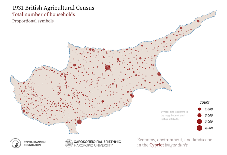
1931, Households, Proportional symbols
1931, Households, Hot spot analysis (Getis-Ord Gi* statistic)
1931, Households, Aggregated in various regions of the island
1931, Households, Aggregated in major drainage basins
1931, Households, Thiessen polygons
1931, Households, Spatial autocorrelation (Moran's I statistic)
1931, Households, Aggregated in 25 sq.km hexagons
1931, Households, Aggregated in 25 sq.km rectangles
1931, Households, Kernel density

Arable land

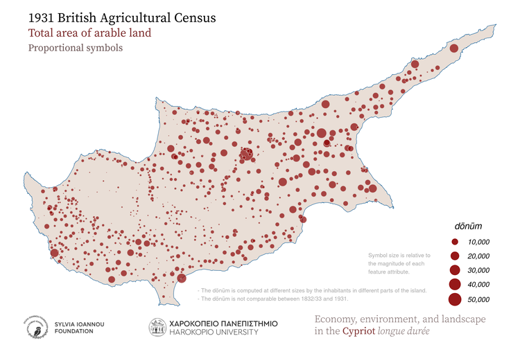
1931, Arable land, Proportional symbols
1931, Arable land, Hot spot analysis (Getis-Ord Gi* statistic)
1931, Arable land, Aggregated in various regions of the island
1931, Arable land, Aggregated in major drainage basins
1931, Arable land, Thiessen polygons
1931, Arable land, Spatial autocorrelation (Moran's I statistic)
1931, Arable land, Aggregated in 25 sq.km hexagons
1931, Arable land, Aggregated in 25 sq.km rectangles
1931, Arable land, Kernel density

Cultivated land

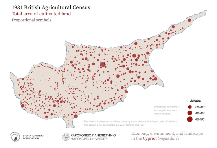
1931, Cultivated land, Proportional symbols
1931, Cultivated land, Hot spot analysis (Getis-Ord Gi* statistic)
1931, Cultivated land, Aggregated in various regions of the island
1931, Cultivated land, Aggregated in major drainage basins
1931, Cultivated land, Thiessen polygons
1931, Cultivated land, Spatial autocorrelation (Moran's I statistic)
1931, Cultivated land, Aggregated in 25 sq.km hexagons
1931, Cultivated land, Aggregated in 25 sq.km rectangles
1931, Cultivated land, Kernel density

Gardens

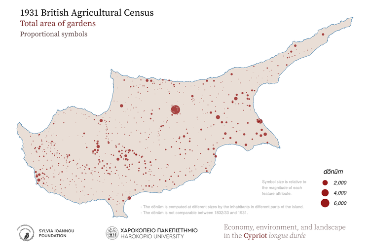
1931, Gardens, Proportional symbols
1931, Gardens, Hot spot analysis (Getis-Ord Gi* statistic)
1931, Gardens, Aggregated in various regions of the island
1931, Gardens, Aggregated in major drainage basins
1931, Gardens, Thiessen polygons
1931, Gardens, Spatial autocorrelation (Moran's I statistic)
1931, Gardens, Aggregated in 25 sq.km hexagons
1931, Gardens, Aggregated in 25 sq.km rectangles
1931, Gardens, Kernel density

Vineyards

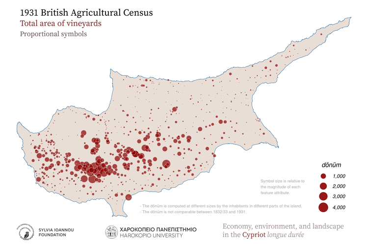
1931, Vineyards, Proportional symbols
1931, Vineyards, Hot spot analysis (Getis-Ord Gi* statistic)
1931, Vineyards, Aggregated in various regions of the island
1931, Vineyards, Aggregated in major drainage basins
1931, Vineyards, Thiessen polygons
1931, Vineyards, Spatial autocorrelation (Moran's I statistic)
1931, Vineyards, Aggregated in 25 sq.km hexagons
1931, Vineyards, Aggregated in 25 sq.km rectangles
1931, Vineyards, Kernel density

Olive trees

1931, Olive trees, Proportional symbols
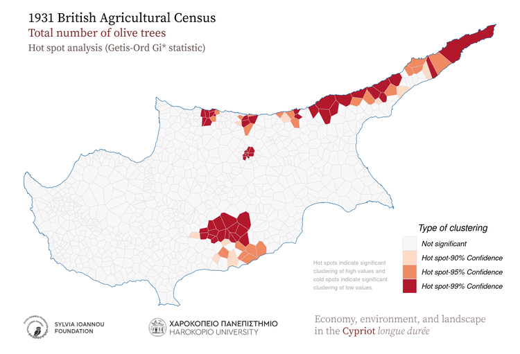
1931, Olive trees, Hot spot analysis (Getis-Ord Gi* statistic)
1931, Olive trees, Aggregated in various regions of the island
1931, Olive trees, Aggregated in major drainage basins
1931, Olive trees, Thiessen polygons
1931, Olive trees, Spatial autocorrelation (Moran's I statistic)
1931, Olive trees, Aggregated in 25 sq.km hexagons
1931, Olive trees, Aggregated in 25 sq.km rectangles
1931, Olive trees, Kernel density

Fruit trees

1931, Fruit trees, Proportional symbols
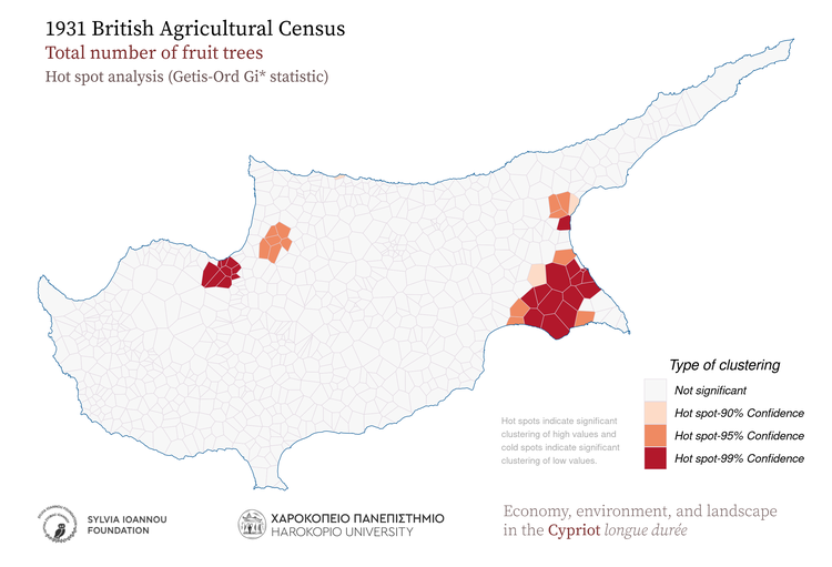
1931, Fruit trees, Hot spot analysis (Getis-Ord Gi* statistic)
1931, Fruit trees, Aggregated in various regions of the island
1931, Fruit trees, Aggregated in major drainage basins
1931, Fruit trees, Thiessen polygons
1931, Fruit trees, Spatial autocorrelation (Moran's I statistic)
1931, Fruit trees, Aggregated in 25 sq.km hexagons
1931, Fruit trees, Aggregated in 25 sq.km rectangles
1931, Fruit trees, Kernel density

Carob trees

1931, Carob trees, Proportional symbols
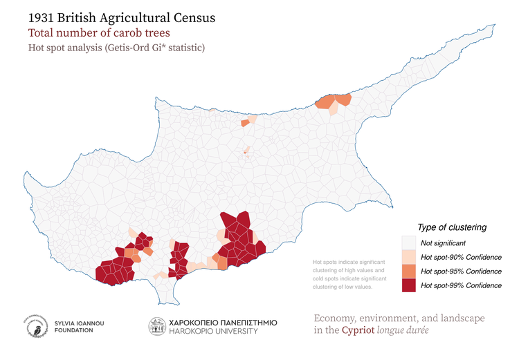
1931, Carob trees, Hot spot analysis (Getis-Ord Gi* statistic)
1931, Carob trees, Aggregated in various regions of the island
1931, Carob trees, Aggregated in major drainage basins
1931, Carob trees, Thiessen polygons
1931, Carob trees, Spatial autocorrelation (Moran's I statistic)
1931, Carob trees, Aggregated in 25 sq.km hexagons
1931, Carob trees, Aggregated in 25 sq.km rectangles
1931, Carob trees, Kernel density

Trees

1931, Trees, Proportional symbols
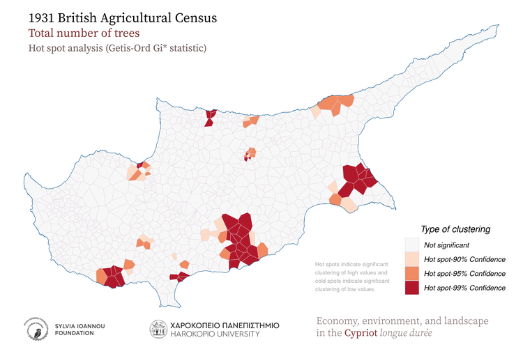
1931, Trees, Hot spot analysis (Getis-Ord Gi* statistic)
1931, Trees, Aggregated in various regions of the island
1931, Trees, Aggregated in major drainage basins
1931, Trees, Thiessen polygons
1931, Trees, Spatial autocorrelation (Moran's I statistic)
1931, Trees, Aggregated in 25 sq.km hexagons
1931, Trees, Aggregated in 25 sq.km rectangles
1931, Trees, Kernel density

Animals

1931, Animals, Proportional symbols
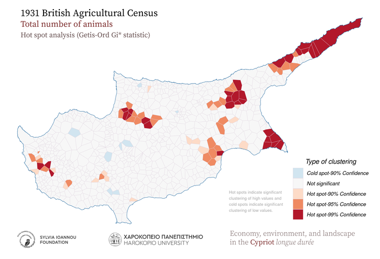
1931, Animals, Hot spot analysis (Getis-Ord Gi* statistic)
1931, Animals, Aggregated in various regions of the island
1931, Animals, Aggregated in major drainage basins
1931, Animals, Thiessen polygons
1931, Animals, Spatial autocorrelation (Moran's I statistic)
1931, Animals, Aggregated in 25 sq.km hexagons
1931, Animals, Aggregated in 25 sq.km rectangles
1931, Animals, Kernel density

Donkeys

1931, Donkeys, Proportional symbols
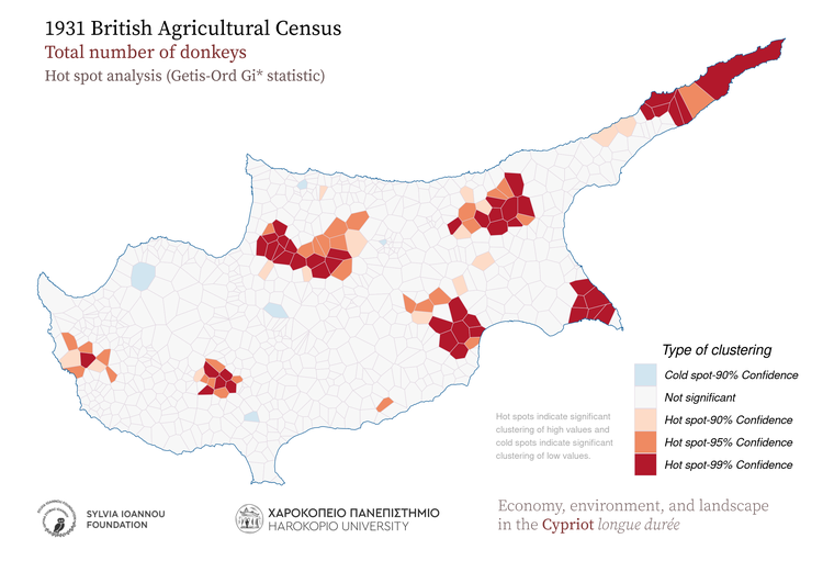
1931, Donkeys, Hot spot analysis (Getis-Ord Gi* statistic)
1931, Donkeys, Aggregated in various regions of the island
1931, Donkeys, Aggregated in major drainage basins
1931, Donkeys, Thiessen polygons
1931, Donkeys, Spatial autocorrelation (Moran's I statistic)
1931, Donkeys, Aggregated in 25 sq.km hexagons
1931, Donkeys, Aggregated in 25 sq.km rectangles
1931, Donkeys, Kernel density

Mules

1931, Mules, Proportional symbols
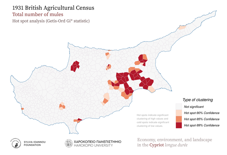
1931, Mules, Hot spot analysis (Getis-Ord Gi* statistic)
1931, Mules, Aggregated in various regions of the island
1931, Mules, Aggregated in major drainage basins
1931, Mules, Thiessen polygons
1931, Mules, Spatial autocorrelation (Moran's I statistic)
1931, Mules, Aggregated in 25 sq.km hexagons
1931, Mules, Aggregated in 25 sq.km rectangles
1931, Mules, Kernel density

Horses

1931, Horses, Proportional symbols
1931, Horses, Hot spot analysis (Getis-Ord Gi* statistic)
1931, Horses, Aggregated in various regions of the island
1931, Horses, Aggregated in major drainage basins
1931, Horses, Thiessen polygons
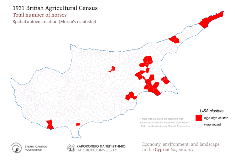
1931, Horses, Spatial autocorrelation (Moran's I statistic)
1931, Horses, Aggregated in 25 sq.km hexagons
1931, Horses, Aggregated in 25 sq.km rectangles
1931, Horses, Kernel density

Oxen

1931, Oxen, Proportional symbols
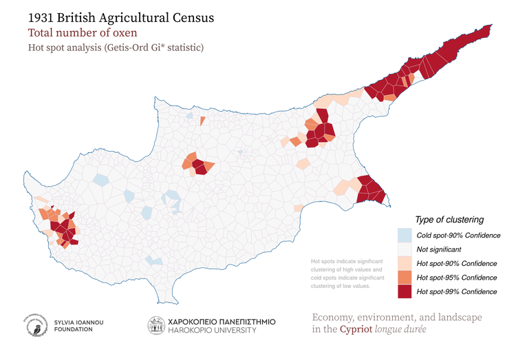
1931, Oxen, Hot spot analysis (Getis-Ord Gi* statistic)
1931, Oxen, Aggregated in various regions of the island
1931, Oxen, Aggregated in major drainage basins
1931, Oxen, Thiessen polygons
1931, Oxen, Spatial autocorrelation (Moran's I statistic)
1931, Oxen, Aggregated in 25 sq.km hexagons
1931, Oxen, Aggregated in 25 sq.km rectangles
1931, Oxen, Kernel density
About the project
  • Description
  • The team
  • Related projects
Sources and methodology
  • The Ottoman 1572 fiscal survey of Cyprus
  • The Ottoman 1832/33 property survey of Cyprus
  • The British 1883 trigonometrical survey of Cyprus by Horatio Herbert Kitchener
  • The British 1931 agricultural census of Cyprus
  • Auxilliary sources
Outcomes from the project
  • Web sites
    • The 1832/33 Ottoman property survey of Cyprus (web site)  
    • Kitchener's 1883 map of Cyprus (web site)  
  • Thematic maps
    • 1572
    • 1832/33
    • 1931
    • Geospatial analysis
  • Publications
    • Academic publications
    • Conferences/lectures
    • Press
  • Educational material
  • Mobile applications
    • Kitchener's 1883 map of Cyprus (mobile application)
    • The River Speaks: Water, Land and People on the Pediaios
The project
Economy, environment, and landscape in the Cypriot longue durée
was developed by
the Geography Department of Harokopio University
and funded by the
Sylvia Ioannou Charitable Foundation
© 2019 - 2023 Copyright
Sylvia Ioannou Charitable Foundation
Geography Department of Harokopio University
All rights reserved.
Contact | Terms of use and privacy policy
This site is protected by reCAPTCHA. Google Privacy Policy and Terms of Service apply.
The use of the 1542 Attar map is kindly permitted by the Correr Museum, Venice. Leonida Attar, Carta geografica dell'isola di Cipro, Venezia, Museo Correr, Gabinetto di cartografia, inv. Cl. XLIV b n. 0534 © Archivio Fotografico - Fondazione Musei Civici di Venezia.
Before you continue
To sum up: Unnecessary cookies refer to Google Analytics. Essential cookies refer to website's user experience cookies and Google's reCaptcha used in our contact form
Last revision on 04/01/2023
Terms of use

Thank you for visiting the "Economy, environment, and landscape in the Cypriot longue durée" website, developed and operated by the Geography Department of Harokopio University (hereafter "Geography Department") with the collaboration of "Sylvia Ioannou Charitable Foundation" (hereafter "SICF") established in Lichtenstein. By using this Website you agree and accept the following terms of use. If you do not agree to the following Terms of Use, please refrain from using this Website. Geography Department and SICF reserve the right to occassionally amend these Terms of Use. The amended text of Terms of Use will be posted on the Website.

Definitions

"Economy, environment, and landscape in the Cypriot longue durée", hereafter "the Website", consists of software and information, specifically the front-end web pages along with material and information stored in our back-end servers and databases.

Copyright

Geography Department of Harokopio University and SICF are the exclusive owners of all copyrights (database rights, intellectual property and industrial property rights etc.) over all the elements of the Website, including its software. All such rights are reserved and protected by the provisions of the Greek copyright laws and international treaties. The Website includes many elements of originality in relation to the selection of the material and the classification of its contents; therefore it qualifies as an original work of authorship which is protected by copyright laws. Please note that the development and operation of this website entails funds kindly provided by SICF and operational resources provided by the Geography Department of Harokopio University.

All access to information contained in the Website (including but not limited to digitised print material, texts, photos, images, video etc.) is permitted only for personal, educational or research purposes. If you author any public text (e.g. an academic or research paper, an article, a blog post etc.) or if you make any public announcement or any kind of presentation using information from this Website, you are obliged to cite this Website as your source. Please use the Citation page for instructions on how to properly cite this Website.

It is forbidden to copy, reproduce, republish, upload to other websites, transmit, upload to a server, distribute, perform to the public, modify, create derivative works and in general to exploit in any way, either wholly or in part, any element of this Website, unless you have been clearly given written permission to do so. In general, it is forbidden to use the Website for commercial purposes or for any other purpose not been explicitly permitted by the Geography Department and SICF.

Extraction and/or reuse of the whole or of a part of the contents of the Website are forbidden. The users of this Website must abstain from any act which conflicts with the normal usage of this Website or which unreasonably confronts the legitimate interests of the Geography Department and SICF.

The trademarks, logos, brands, trade names, distinctive titles contained in the Website, registered or not, are owned by the Geography Department and SICF or by third party business associates of the Geography Department and SICF and are protected according to the law. Nothing herein shall be deemed to confer on the user a license to use the above trademarks and/or distinctive marks, any reproduction or use of which is strictly forbidden.

User-generated and User-submitted content

The Website offers the means for any content to be submitted to the Geography Department (either by filling the contact form or by sending e-mail). This content can be anything that can be transferred electronically (text, image, video, etc.) Any content that you submit to the Website must be your own original work and cannot contain, incorporate or reference anything that is owned by any third party or entity or would require the consent of any third party or entity in any jurisdiction (this restriction includes the depiction of individuals or any personal identification). By sending the content you declare and warrant that it is not illegal, offensive or defamatory and you explicitly grant to the Geography Department and SICF the irrevocable and unlimited permission to use the content and the right to upload the content to the Website without royalty, payment or other compensation.  If the sender wishes for proper attribution to appear on the Website, they should include the relevant information in the form or their e-mail. The sender should be aware that the content may appear or be posted to social media platforms by the Geography Department or users of the Website. The Geography Department and SICF reserve the right in their discretion to decide if the content is usable and publishable for the Website. The Geography Department and SICF may publish, review, modify or remove all or part of the content submitted at their discretion.

Website access

The Geography Department makes every effort to ensure that the Website is accessible for 24 hours a day. However, the Geography Department shall not be liable if‚ for any reason‚ the Website is unavailable or if the connection is interrupted or faulty. The Geography Department does not guarantee that the Website will be secure. Please confirm that your electronic equipment is free from viruses and in excellent condition.

Quality of information posted and limitation of liability

The Geography Department will do everything in its power to ensure the quality of information disseminated through the Website. However, the Geography Department and SICF do not fully guarantee the accuracy, completeness or reliability of the information due to the great volume and their particular characteristics of the data contained on the Website. The Website provides its information on an “as is” basis; therefore the Geography Department and SICF shall not be liable for any direct or indirect loss which may arise from information which is inaccurate, incomplete or is infringing third party rights.

The SICF and the Geography Department (including its employees / contractors which operate the Website) decline any and all liability for any loss (direct or indirect) which may arise as a result of your access, use or inability to access the Website.

The Geography Department and SICF reserve the right, at their discretion:

  1. to make alterations to the Website and its contents from time to time, without prior notice, even if the access to the Website is temporarily interrupted and
  2. to disable access to the Website, either wholly or in part, and/ or to remove any archive, element or information contained.

The above limitations of liability apply to the fullest extent permitted by law.

Prohibited uses of the Website

All users must not use the Website in any manner, which at the discretion of the Geography Department and SICF, is improper and / or violates Greek or EU laws.

Prohibited uses of the Website include but are not limited to the following:

  • Acts which violate the copyright and industrial property rights of the Geography Department and SICF over the Website, its software, trademarks, logos, distinctive titles etc.

  • Acts which violate either the privacy right of a third party (such as the unauthorized disclosure of personal data) or other third-party rights.

  • Any unauthorized access or attack to the Website, such as introducing viruses or other malicious material to Geography Department's servers or electronic systems.

In case access to the Website is granted to subscribed or authorized users, the Geography Department and SICF reserve the right to cancel access to any user account at any time, if they believe that the user has breached the law and / or the present Terms of Use.

Linking to other websites

The Website contains links to external resources and websites operated by third parties. The Geography Department and SICF does not have control over these websites and therefore are not responsible for the availability, content, advertisements, goods, services or any other material contained on or available through external websites.

Applicable law

These Terms of Use, any amendment thereof and the use of the Website are subject to the Greek law. Any claim arising out of the use of the Website shall be brought only before the Courts of Athens, Greece.

Privacy Policy

Definitions

  • Harokopio University, Geography Department:
  • GDPR: General Data Protection Regulation Act.
  • Data Controller: Data Controller means the natural or legal person who (either alone or jointly or in common with other persons) determines the purposes for which and the manner in which any personal information are, or are to be, processed.
  • Data Processor: Data Processor means any natural or legal person who processes the data on behalf of the Data Controller.
  • Data Subject: Data Subject is any living individual who is using our Service and is the subject of Personal Data.

1. Principles for processing personal data

Our principles for processing personal data are:

  • Fairness and lawfulness. When we process personal data, the individual rights of the Data Subjects must be protected. All personal data must be collected and processed in a legal and fair manner.
  • Restricted to a specific purpose. The personal data of Data Subject must be processed only for specific purposes.
  • Transparency. The Data Subject must be informed of how his/her data is being collected, processed and used.

2. What personal data we collect and process

For registered users, the Geography Department of Harokopio University collects several different types of personal data for various purposes. Personal Data may include, but is not limited to:

  • Email address
  • First name and last name
  • Address, State, Province, ZIP/Postal code, City
For unregistered users, we do not collect any personal data.
For all users, we use:
  • Web app cookies for web application settings and session management
  • Google Analytics to improve our services.
Web app cookies are an integral part of the application. To prevent your data from being used by Google Analytics, you can use the Google Analytics opt-out browser add-on for the Google Analytics JavaScript (ga.js, analytics.js, dc.js). If you want to opt-out, download and install the add-on for your web browser. The Google Analytics opt-out add-on is designed to be compatible with Chrome, Internet Explorer 11, Safari, Firefox and Opera. In order to function, the opt-out add-on must be able to load and execute properly on your browser. For Internet Explorer, 3rd-party cookies must be enabled. Learn more about the opt-out and how to properly install the browser add-on here.

3. How we use the personal data

Geography Department uses the collected personal data for various purposes:

  • To provide you with services
  • To notify you about changes to our services and/or products
  • To provide user support
  • To gather analysis or valuable information so that we can improve our services
  • To detect, prevent and address technical issues
  • To allow content entry and management
  • To enforce our legal rights
  • To detect potential breaches of the Terms of Use
  • To comply with any legal requirements to which we are subject

4. Legal basis for collecting and processing personal data

Geography's Department legal basis for collecting and using the personal data described in this Data Protection Policy depends on the personal data we collect and the specific context in which we collect the information:

  • Geography Department needs to perform a contract with you
  • You have given Geography Department permission to do so
  • Processing your personal data is in Geography's Department legitimate interests
  • Geography Department needs to comply with the law

5. Retention of personal data

Geography Department will retain your personal information only for as long as is necessary for the purposes set out in this Data Protection Policy. Geography Department will retain and use your information to the extent necessary to comply with our legal obligations, resolve disputes, and enforce our policies.
6. Data protection rights

If you are a resident of the European Economic Area (EEA), you have certain data protection rights. If you wish to be informed what personal data we hold about you and if you want it to be removed from our systems, please contact us. In certain circumstances, you have the following data protection rights:

  • The right to access, update or to delete the information we have on you
  • The right of rectification
  • The right to object
  • The right of restriction
  • The right to data portability
  • The right to withdraw consent

7. Queries

If you have any questions regarding this Privacy Policy or any data collected under the Privacy Policy, you can contact Geography's Department at gaia_webmaster [at] hua.gr. Please note that you have a right to lodge a complaint with the Hellenic Data Protection Authority at http://www.dpa.gr. 

8. Changes to our privacy policy

 We may occasionally amend this Privacy Policy to account for changes to our services and the way we handle your personal information. Therefore, we suggest that you frequently visit this Privacy Policy.