Maps showing data from the 1832/33 Ottoman property survey


All properties (values)

1833, All properties (values), Proportional symbols
1832/33 Ottoman Property survey Total value of all properties Proportional symbols Symbol size is relative to the magnitude of each feature attribute. kuruş Harokopio University Sylvia Ioannou foundation Economy, environment, and landscape in the Cypriot longue durée
1833, All properties (values), Hot spot analysis (Getis-Ord Gi* statistic)
1832/33 Ottoman Property survey Total value of all properties Hot spot analysis (Getis-Ord Gi* statistic) Hot spots indicate significant clustering of high values and cold spots indicate significant clustering of low values. kuruş Harokopio University Sylvia Ioannou foundation Economy, environment, and landscape in the Cypriot longue durée
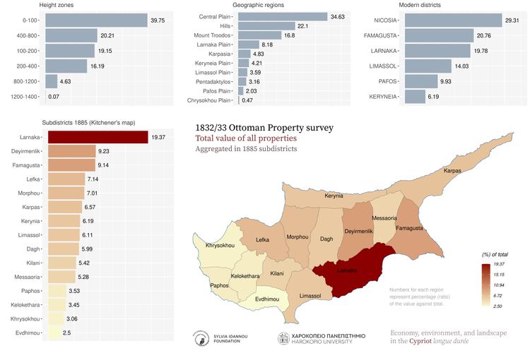
1833, All properties (values), Aggregated in various regions of the island
1832/33 Ottoman Property survey Total value of all properties Aggregated in 1885 subdistricts Subdistricts 1885 (Kitchener's map) Modern districts Height zones Geographic regions kuruş Harokopio University Sylvia Ioannou foundation Economy, environment, and landscape in the Cypriot longue durée
1833, All properties (values), Aggregated in major drainage basins
1832/33 Ottoman Property survey Total value of all properties Aggregated in major drainage basins kuruş Harokopio University Sylvia Ioannou foundation Economy, environment, and landscape in the Cypriot longue durée
1833, All properties (values), Thiessen polygons
1832/33 Ottoman Property survey Total value of all properties Thiessen polygons Gray areas indicate zero values for the variable. Comma in the legend is used as thousands separator kuruş Harokopio University Sylvia Ioannou foundation Economy, environment, and landscape in the Cypriot longue durée
1833, All properties (values), Spatial autocorrelation (Moran's I statistic)
1832/33 Ottoman Property survey Total value of all properties Spatial autocorrelation (Moran's I) A high-high cluster is an area with high value surrounded by areas with high values. LISA: Local Indicators οf Spatial Association kuruş Harokopio University Sylvia Ioannou foundation Economy, environment, and landscape in the Cypriot longue durée
1833, All properties (values), Aggregated in 25 sq.km hexagons
1832/33 Ottoman Property survey Total value of all properties Aggregated in 25 Km^2 hexagons Comma in the legend is used as thousands separator kuruş Harokopio University Sylvia Ioannou foundation Economy, environment, and landscape in the Cypriot longue durée
1833, All properties (values), Aggregated in 25 sq.km rectangles
1832/33 Ottoman Property survey Total value of all properties Aggregated in 25 Km^2 rectangles Comma in the legend is used as thousands separator kuruş Harokopio University Sylvia Ioannou foundation Economy, environment, and landscape in the Cypriot longue durée
1833, All properties (values), Kernel density
1832/33 Ottoman Property survey Total value of all properties Kernel density Shades of red color indicate high density of the mapped variable kuruş Harokopio University Sylvia Ioannou foundation Economy, environment, and landscape in the Cypriot longue durée

Households

1833, Households, Proportional symbols
1832/33 Ottoman Property survey Total number of households Proportional symbols Symbol size is relative to the magnitude of each feature attribute. count Harokopio University Sylvia Ioannou foundation Economy, environment, and landscape in the Cypriot longue durée
1833, Households, Hot spot analysis (Getis-Ord Gi* statistic)
1832/33 Ottoman Property survey Total number of households Hot spot analysis (Getis-Ord Gi* statistic) Hot spots indicate significant clustering of high values and cold spots indicate significant clustering of low values. count Harokopio University Sylvia Ioannou foundation Economy, environment, and landscape in the Cypriot longue durée
1833, Households, Aggregated in various regions of the island
1832/33 Ottoman Property survey Total number of households Aggregated in 1885 subdistricts Subdistricts 1885 (Kitchener's map) Modern districts Height zones Geographic regions count Harokopio University Sylvia Ioannou foundation Economy, environment, and landscape in the Cypriot longue durée
1833, Households, Aggregated in major drainage basins
1832/33 Ottoman Property survey Total number of households Aggregated in major drainage basins count Harokopio University Sylvia Ioannou foundation Economy, environment, and landscape in the Cypriot longue durée
1833, Households, Thiessen polygons
1832/33 Ottoman Property survey Total number of households Thiessen polygons Gray areas indicate zero values for the variable. Comma in the legend is used as thousands separator count Harokopio University Sylvia Ioannou foundation Economy, environment, and landscape in the Cypriot longue durée
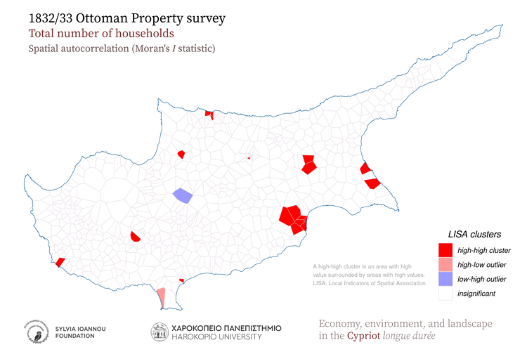
1833, Households, Spatial autocorrelation (Moran's I statistic)
1832/33 Ottoman Property survey Total number of households Spatial autocorrelation (Moran's I) A high-high cluster is an area with high value surrounded by areas with high values. LISA: Local Indicators οf Spatial Association count Harokopio University Sylvia Ioannou foundation Economy, environment, and landscape in the Cypriot longue durée
1833, Households, Aggregated in 25 sq.km hexagons
1832/33 Ottoman Property survey Total number of households Aggregated in 25 Km^2 hexagons Comma in the legend is used as thousands separator count Harokopio University Sylvia Ioannou foundation Economy, environment, and landscape in the Cypriot longue durée
1833, Households, Aggregated in 25 sq.km rectangles
1832/33 Ottoman Property survey Total number of households Aggregated in 25 Km^2 rectangles Comma in the legend is used as thousands separator count Harokopio University Sylvia Ioannou foundation Economy, environment, and landscape in the Cypriot longue durée
1833, Households, Kernel density
1832/33 Ottoman Property survey Total number of households Kernel density Shades of red color indicate high density of the mapped variable count Harokopio University Sylvia Ioannou foundation Economy, environment, and landscape in the Cypriot longue durée

Grain fields (value)

1833, Grain fields (value), Proportional symbols
1832/33 Ottoman Property survey Total value of grain fields Proportional symbols Symbol size is relative to the magnitude of each feature attribute. kuruş Harokopio University Sylvia Ioannou foundation Economy, environment, and landscape in the Cypriot longue durée
1833, Grain fields (value), Hot spot analysis (Getis-Ord Gi* statistic)
1832/33 Ottoman Property survey Total value of grain fields Hot spot analysis (Getis-Ord Gi* statistic) Hot spots indicate significant clustering of high values and cold spots indicate significant clustering of low values. kuruş Harokopio University Sylvia Ioannou foundation Economy, environment, and landscape in the Cypriot longue durée
1833, Grain fields (value), Aggregated in various regions of the island
1832/33 Ottoman Property survey Total value of grain fields Aggregated in 1885 subdistricts Subdistricts 1885 (Kitchener's map) Modern districts Height zones Geographic regions kuruş Harokopio University Sylvia Ioannou foundation Economy, environment, and landscape in the Cypriot longue durée
1833, Grain fields (value), Aggregated in major drainage basins
1832/33 Ottoman Property survey Total value of grain fields Aggregated in major drainage basins kuruş Harokopio University Sylvia Ioannou foundation Economy, environment, and landscape in the Cypriot longue durée
1833, Grain fields (value), Thiessen polygons
1832/33 Ottoman Property survey Total value of grain fields Thiessen polygons Gray areas indicate zero values for the variable. Comma in the legend is used as thousands separator kuruş Harokopio University Sylvia Ioannou foundation Economy, environment, and landscape in the Cypriot longue durée
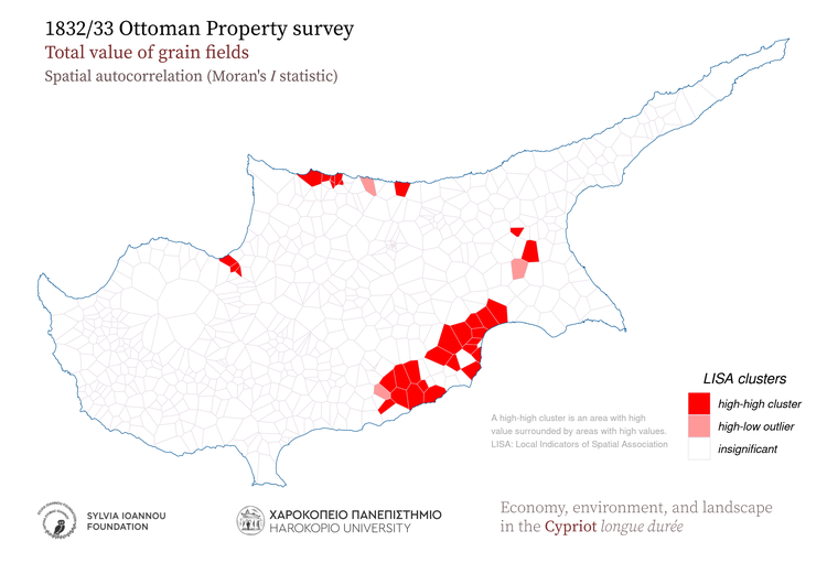
1833, Grain fields (value), Spatial autocorrelation (Moran's I statistic)
1832/33 Ottoman Property survey Total value of grain fields Spatial autocorrelation (Moran's I) A high-high cluster is an area with high value surrounded by areas with high values. LISA: Local Indicators οf Spatial Association kuruş Harokopio University Sylvia Ioannou foundation Economy, environment, and landscape in the Cypriot longue durée
1833, Grain fields (value), Aggregated in 25 sq.km hexagons
1832/33 Ottoman Property survey Total value of grain fields Aggregated in 25 Km^2 hexagons Comma in the legend is used as thousands separator kuruş Harokopio University Sylvia Ioannou foundation Economy, environment, and landscape in the Cypriot longue durée
1833, Grain fields (value), Aggregated in 25 sq.km rectangles
1832/33 Ottoman Property survey Total value of grain fields Aggregated in 25 Km^2 rectangles Comma in the legend is used as thousands separator kuruş Harokopio University Sylvia Ioannou foundation Economy, environment, and landscape in the Cypriot longue durée
1833, Grain fields (value), Kernel density
1832/33 Ottoman Property survey Total value of grain fields Kernel density Shades of red color indicate high density of the mapped variable kuruş Harokopio University Sylvia Ioannou foundation Economy, environment, and landscape in the Cypriot longue durée

Olives

1833, Olives, Proportional symbols
1832/33 Ottoman Property survey Total value of Olives Proportional symbols Symbol size is relative to the magnitude of each feature attribute. kuruş Harokopio University Sylvia Ioannou foundation Economy, environment, and landscape in the Cypriot longue durée
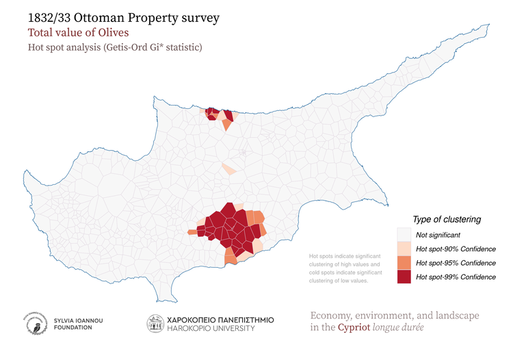
1833, Olives, Hot spot analysis (Getis-Ord Gi* statistic)
1832/33 Ottoman Property survey Total value of Olives Hot spot analysis (Getis-Ord Gi* statistic) Hot spots indicate significant clustering of high values and cold spots indicate significant clustering of low values. kuruş Harokopio University Sylvia Ioannou foundation Economy, environment, and landscape in the Cypriot longue durée
1833, Olives, Aggregated in various regions of the island
1832/33 Ottoman Property survey Total value of Olives Aggregated in 1885 subdistricts Subdistricts 1885 (Kitchener's map) Modern districts Height zones Geographic regions kuruş Harokopio University Sylvia Ioannou foundation Economy, environment, and landscape in the Cypriot longue durée
1833, Olives, Aggregated in major drainage basins
1832/33 Ottoman Property survey Total value of Olives Aggregated in major drainage basins kuruş Harokopio University Sylvia Ioannou foundation Economy, environment, and landscape in the Cypriot longue durée
1833, Olives, Thiessen polygons
1832/33 Ottoman Property survey Total value of Olives Thiessen polygons Gray areas indicate zero values for the variable. Comma in the legend is used as thousands separator kuruş Harokopio University Sylvia Ioannou foundation Economy, environment, and landscape in the Cypriot longue durée
1833, Olives, Spatial autocorrelation (Moran's I statistic)
1832/33 Ottoman Property survey Total value of Olives Spatial autocorrelation (Moran's I) A high-high cluster is an area with high value surrounded by areas with high values. LISA: Local Indicators οf Spatial Association kuruş Harokopio University Sylvia Ioannou foundation Economy, environment, and landscape in the Cypriot longue durée
1833, Olives, Aggregated in 25 sq.km hexagons
1832/33 Ottoman Property survey Total value of Olives Aggregated in 25 Km^2 hexagons Comma in the legend is used as thousands separator kuruş Harokopio University Sylvia Ioannou foundation Economy, environment, and landscape in the Cypriot longue durée
1833, Olives, Aggregated in 25 sq.km rectangles
1832/33 Ottoman Property survey Total value of Olives Aggregated in 25 Km^2 rectangles Comma in the legend is used as thousands separator kuruş Harokopio University Sylvia Ioannou foundation Economy, environment, and landscape in the Cypriot longue durée
1833, Olives, Kernel density
1832/33 Ottoman Property survey Total value of Olives Kernel density Shades of red color indicate high density of the mapped variable kuruş Harokopio University Sylvia Ioannou foundation Economy, environment, and landscape in the Cypriot longue durée

Vineyards

1833, Vineyards, Proportional symbols
1832/33 Ottoman Property survey Total value of vineyards Proportional symbols Symbol size is relative to the magnitude of each feature attribute. kuruş Harokopio University Sylvia Ioannou foundation Economy, environment, and landscape in the Cypriot longue durée
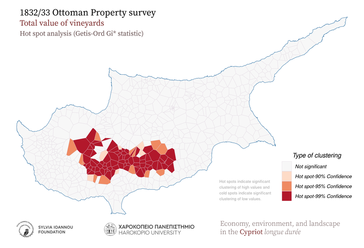
1833, Vineyards, Hot spot analysis (Getis-Ord Gi* statistic)
1832/33 Ottoman Property survey Total value of vineyards Hot spot analysis (Getis-Ord Gi* statistic) Hot spots indicate significant clustering of high values and cold spots indicate significant clustering of low values. kuruş Harokopio University Sylvia Ioannou foundation Economy, environment, and landscape in the Cypriot longue durée
1833, Vineyards, Aggregated in various regions of the island
1832/33 Ottoman Property survey Total value of vineyards Aggregated in 1885 subdistricts Subdistricts 1885 (Kitchener's map) Modern districts Height zones Geographic regions kuruş Harokopio University Sylvia Ioannou foundation Economy, environment, and landscape in the Cypriot longue durée
1833, Vineyards, Aggregated in major drainage basins
1832/33 Ottoman Property survey Total value of vineyards Aggregated in major drainage basins kuruş Harokopio University Sylvia Ioannou foundation Economy, environment, and landscape in the Cypriot longue durée
1833, Vineyards, Thiessen polygons
1832/33 Ottoman Property survey Total value of vineyards Thiessen polygons Gray areas indicate zero values for the variable. Comma in the legend is used as thousands separator kuruş Harokopio University Sylvia Ioannou foundation Economy, environment, and landscape in the Cypriot longue durée
1833, Vineyards, Spatial autocorrelation (Moran's I statistic)
1832/33 Ottoman Property survey Total value of vineyards Spatial autocorrelation (Moran's I) A high-high cluster is an area with high value surrounded by areas with high values. LISA: Local Indicators οf Spatial Association kuruş Harokopio University Sylvia Ioannou foundation Economy, environment, and landscape in the Cypriot longue durée
1833, Vineyards, Aggregated in 25 sq.km hexagons
1832/33 Ottoman Property survey Total value of vineyards Aggregated in 25 Km^2 hexagons Comma in the legend is used as thousands separator kuruş Harokopio University Sylvia Ioannou foundation Economy, environment, and landscape in the Cypriot longue durée
1833, Vineyards, Aggregated in 25 sq.km rectangles
1832/33 Ottoman Property survey Total value of vineyards Aggregated in 25 Km^2 rectangles Comma in the legend is used as thousands separator kuruş Harokopio University Sylvia Ioannou foundation Economy, environment, and landscape in the Cypriot longue durée
1833, Vineyards, Kernel density
1832/33 Ottoman Property survey Total value of vineyards Kernel density Shades of red color indicate high density of the mapped variable kuruş Harokopio University Sylvia Ioannou foundation Economy, environment, and landscape in the Cypriot longue durée

Carobs

1833, Carobs, Proportional symbols
1832/33 Ottoman Property survey Total value of Carobs Proportional symbols Symbol size is relative to the magnitude of each feature attribute. kuruş Harokopio University Sylvia Ioannou foundation Economy, environment, and landscape in the Cypriot longue durée
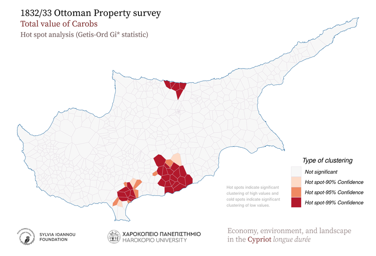
1833, Carobs, Hot spot analysis (Getis-Ord Gi* statistic)
1832/33 Ottoman Property survey Total value of Carobs Hot spot analysis (Getis-Ord Gi* statistic) Hot spots indicate significant clustering of high values and cold spots indicate significant clustering of low values. kuruş Harokopio University Sylvia Ioannou foundation Economy, environment, and landscape in the Cypriot longue durée
1833, Carobs, Aggregated in various regions of the island
1832/33 Ottoman Property survey Total value of Carobs Aggregated in 1885 subdistricts Subdistricts 1885 (Kitchener's map) Modern districts Height zones Geographic regions kuruş Harokopio University Sylvia Ioannou foundation Economy, environment, and landscape in the Cypriot longue durée
1833, Carobs, Aggregated in major drainage basins
1832/33 Ottoman Property survey Total value of Carobs Aggregated in major drainage basins kuruş Harokopio University Sylvia Ioannou foundation Economy, environment, and landscape in the Cypriot longue durée
1833, Carobs, Thiessen polygons
1832/33 Ottoman Property survey Total value of Carobs Thiessen polygons Gray areas indicate zero values for the variable. Comma in the legend is used as thousands separator kuruş Harokopio University Sylvia Ioannou foundation Economy, environment, and landscape in the Cypriot longue durée
1833, Carobs, Spatial autocorrelation (Moran's I statistic)
1832/33 Ottoman Property survey Total value of Carobs Spatial autocorrelation (Moran's I) A high-high cluster is an area with high value surrounded by areas with high values. LISA: Local Indicators οf Spatial Association kuruş Harokopio University Sylvia Ioannou foundation Economy, environment, and landscape in the Cypriot longue durée
1833, Carobs, Aggregated in 25 sq.km hexagons
1832/33 Ottoman Property survey Total value of Carobs Aggregated in 25 Km^2 hexagons Comma in the legend is used as thousands separator kuruş Harokopio University Sylvia Ioannou foundation Economy, environment, and landscape in the Cypriot longue durée
1833, Carobs, Aggregated in 25 sq.km rectangles
1832/33 Ottoman Property survey Total value of Carobs Aggregated in 25 Km^2 rectangles Comma in the legend is used as thousands separator kuruş Harokopio University Sylvia Ioannou foundation Economy, environment, and landscape in the Cypriot longue durée
1833, Carobs, Kernel density
1832/33 Ottoman Property survey Total value of Carobs Kernel density Shades of red color indicate high density of the mapped variable kuruş Harokopio University Sylvia Ioannou foundation Economy, environment, and landscape in the Cypriot longue durée

Mullberries

1833, Mullberries, Proportional symbols
1832/33 Ottoman Property survey Total value of Mullberries Proportional symbols Symbol size is relative to the magnitude of each feature attribute. kuruş Harokopio University Sylvia Ioannou foundation Economy, environment, and landscape in the Cypriot longue durée
1833, Mullberries, Hot spot analysis (Getis-Ord Gi* statistic)
1832/33 Ottoman Property survey Total value of Mullberries Hot spot analysis (Getis-Ord Gi* statistic) Hot spots indicate significant clustering of high values and cold spots indicate significant clustering of low values. kuruş Harokopio University Sylvia Ioannou foundation Economy, environment, and landscape in the Cypriot longue durée
1833, Mullberries, Aggregated in various regions of the island
1832/33 Ottoman Property survey Total value of Mullberries Aggregated in 1885 subdistricts Subdistricts 1885 (Kitchener's map) Modern districts Height zones Geographic regions kuruş Harokopio University Sylvia Ioannou foundation Economy, environment, and landscape in the Cypriot longue durée
1833, Mullberries, Aggregated in major drainage basins
1832/33 Ottoman Property survey Total value of Mullberries Aggregated in major drainage basins kuruş Harokopio University Sylvia Ioannou foundation Economy, environment, and landscape in the Cypriot longue durée
1833, Mullberries, Thiessen polygons
1832/33 Ottoman Property survey Total value of Mullberries Thiessen polygons Gray areas indicate zero values for the variable. Comma in the legend is used as thousands separator kuruş Harokopio University Sylvia Ioannou foundation Economy, environment, and landscape in the Cypriot longue durée
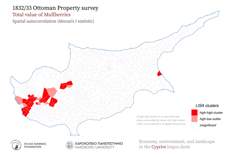
1833, Mullberries, Spatial autocorrelation (Moran's I statistic)
1832/33 Ottoman Property survey Total value of Mullberries Spatial autocorrelation (Moran's I) A high-high cluster is an area with high value surrounded by areas with high values. LISA: Local Indicators οf Spatial Association kuruş Harokopio University Sylvia Ioannou foundation Economy, environment, and landscape in the Cypriot longue durée
1833, Mullberries, Aggregated in 25 sq.km hexagons
1832/33 Ottoman Property survey Total value of Mullberries Aggregated in 25 Km^2 hexagons Comma in the legend is used as thousands separator kuruş Harokopio University Sylvia Ioannou foundation Economy, environment, and landscape in the Cypriot longue durée
1833, Mullberries, Aggregated in 25 sq.km rectangles
1832/33 Ottoman Property survey Total value of Mullberries Aggregated in 25 Km^2 rectangles Comma in the legend is used as thousands separator kuruş Harokopio University Sylvia Ioannou foundation Economy, environment, and landscape in the Cypriot longue durée
1833, Mullberries, Kernel density
1832/33 Ottoman Property survey Total value of Mullberries Kernel density Shades of red color indicate high density of the mapped variable kuruş Harokopio University Sylvia Ioannou foundation Economy, environment, and landscape in the Cypriot longue durée

Cotton fields (area)

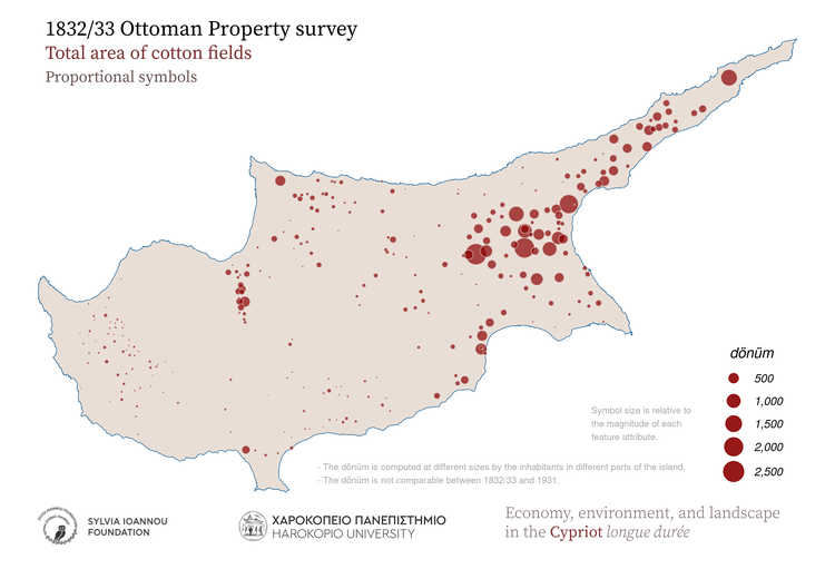
1833, Cotton fields (area), Proportional symbols
1832/33 Ottoman Property survey Total area of cotton fields Proportional symbols Symbol size is relative to the magnitude of each feature attribute. dönüm - The dönüm is computed at different sizes by the inhabitants in different parts of the island. - The dönüm is not comparable between 1832/33 and 1931. Harokopio University Sylvia Ioannou foundation Economy, environment, and landscape in the Cypriot longue durée
1833, Cotton fields (area), Hot spot analysis (Getis-Ord Gi* statistic)
1832/33 Ottoman Property survey Total area of cotton fields Hot spot analysis (Getis-Ord Gi* statistic) Hot spots indicate significant clustering of high values and cold spots indicate significant clustering of low values. dönüm - The dönüm is computed at different sizes by the inhabitants in different parts of the island. - The dönüm is not comparable between 1832/33 and 1931. Harokopio University Sylvia Ioannou foundation Economy, environment, and landscape in the Cypriot longue durée
1833, Cotton fields (area), Aggregated in various regions of the island
1832/33 Ottoman Property survey Total area of cotton fields Aggregated in 1885 subdistricts Subdistricts 1885 (Kitchener's map) Modern districts Height zones Geographic regions dönüm - The dönüm is computed at different sizes by the inhabitants in different parts of the island. - The dönüm is not comparable between 1832/33 and 1931. Harokopio University Sylvia Ioannou foundation Economy, environment, and landscape in the Cypriot longue durée
1833, Cotton fields (area), Aggregated in major drainage basins
1832/33 Ottoman Property survey Total area of cotton fields Aggregated in major drainage basins dönüm - The dönüm is computed at different sizes by the inhabitants in different parts of the island. - The dönüm is not comparable between 1832/33 and 1931. Harokopio University Sylvia Ioannou foundation Economy, environment, and landscape in the Cypriot longue durée
1833, Cotton fields (area), Thiessen polygons
1832/33 Ottoman Property survey Total area of cotton fields Thiessen polygons Gray areas indicate zero values for the variable. Comma in the legend is used as thousands separator dönüm - The dönüm is computed at different sizes by the inhabitants in different parts of the island. - The dönüm is not comparable between 1832/33 and 1931. Harokopio University Sylvia Ioannou foundation Economy, environment, and landscape in the Cypriot longue durée
1833, Cotton fields (area), Spatial autocorrelation (Moran's I statistic)
1832/33 Ottoman Property survey Total area of cotton fields Spatial autocorrelation (Moran's I) A high-high cluster is an area with high value surrounded by areas with high values. LISA: Local Indicators οf Spatial Association dönüm - The dönüm is computed at different sizes by the inhabitants in different parts of the island. - The dönüm is not comparable between 1832/33 and 1931. Harokopio University Sylvia Ioannou foundation Economy, environment, and landscape in the Cypriot longue durée
1833, Cotton fields (area), Aggregated in 25 sq.km hexagons
1832/33 Ottoman Property survey Total area of cotton fields Aggregated in 25 Km^2 hexagons Comma in the legend is used as thousands separator dönüm - The dönüm is computed at different sizes by the inhabitants in different parts of the island. - The dönüm is not comparable between 1832/33 and 1931. Harokopio University Sylvia Ioannou foundation Economy, environment, and landscape in the Cypriot longue durée
1833, Cotton fields (area), Aggregated in 25 sq.km rectangles
1832/33 Ottoman Property survey Total area of cotton fields Aggregated in 25 Km^2 rectangles Comma in the legend is used as thousands separator dönüm - The dönüm is computed at different sizes by the inhabitants in different parts of the island. - The dönüm is not comparable between 1832/33 and 1931. Harokopio University Sylvia Ioannou foundation Economy, environment, and landscape in the Cypriot longue durée
1833, Cotton fields (area), Kernel density
1832/33 Ottoman Property survey Total area of cotton fields Kernel density Shades of red color indicate high density of the mapped variable dönüm - The dönüm is computed at different sizes by the inhabitants in different parts of the island. - The dönüm is not comparable between 1832/33 and 1931. Harokopio University Sylvia Ioannou foundation Economy, environment, and landscape in the Cypriot longue durée

Cotton fields (value)

1833, Cotton fields (value), Proportional symbols
1832/33 Ottoman Property survey Total value of cotton fields Proportional symbols Symbol size is relative to the magnitude of each feature attribute. kuruş Harokopio University Sylvia Ioannou foundation Economy, environment, and landscape in the Cypriot longue durée
1833, Cotton fields (value), Hot spot analysis (Getis-Ord Gi* statistic)
1832/33 Ottoman Property survey Total value of cotton fields Hot spot analysis (Getis-Ord Gi* statistic) Hot spots indicate significant clustering of high values and cold spots indicate significant clustering of low values. kuruş Harokopio University Sylvia Ioannou foundation Economy, environment, and landscape in the Cypriot longue durée
1833, Cotton fields (value), Aggregated in various regions of the island
1832/33 Ottoman Property survey Total value of cotton fields Aggregated in 1885 subdistricts Subdistricts 1885 (Kitchener's map) Modern districts Height zones Geographic regions kuruş Harokopio University Sylvia Ioannou foundation Economy, environment, and landscape in the Cypriot longue durée
1833, Cotton fields (value), Aggregated in major drainage basins
1832/33 Ottoman Property survey Total value of cotton fields Aggregated in major drainage basins kuruş Harokopio University Sylvia Ioannou foundation Economy, environment, and landscape in the Cypriot longue durée
1833, Cotton fields (value), Thiessen polygons
1832/33 Ottoman Property survey Total value of cotton fields Thiessen polygons Gray areas indicate zero values for the variable. Comma in the legend is used as thousands separator kuruş Harokopio University Sylvia Ioannou foundation Economy, environment, and landscape in the Cypriot longue durée
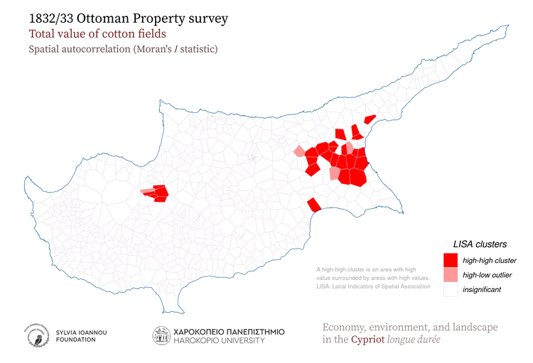
1833, Cotton fields (value), Spatial autocorrelation (Moran's I statistic)
1832/33 Ottoman Property survey Total value of cotton fields Spatial autocorrelation (Moran's I) A high-high cluster is an area with high value surrounded by areas with high values. LISA: Local Indicators οf Spatial Association kuruş Harokopio University Sylvia Ioannou foundation Economy, environment, and landscape in the Cypriot longue durée
1833, Cotton fields (value), Aggregated in 25 sq.km hexagons
1832/33 Ottoman Property survey Total value of cotton fields Aggregated in 25 Km^2 hexagons Comma in the legend is used as thousands separator kuruş Harokopio University Sylvia Ioannou foundation Economy, environment, and landscape in the Cypriot longue durée
1833, Cotton fields (value), Aggregated in 25 sq.km rectangles
1832/33 Ottoman Property survey Total value of cotton fields Aggregated in 25 Km^2 rectangles Comma in the legend is used as thousands separator kuruş Harokopio University Sylvia Ioannou foundation Economy, environment, and landscape in the Cypriot longue durée
1833, Cotton fields (value), Kernel density
1832/33 Ottoman Property survey Total value of cotton fields Kernel density Shades of red color indicate high density of the mapped variable kuruş Harokopio University Sylvia Ioannou foundation Economy, environment, and landscape in the Cypriot longue durée

Horses

1833, Horses, Proportional symbols
1832/33 Ottoman Property survey Total value of horses Proportional symbols Symbol size is relative to the magnitude of each feature attribute. kuruş Harokopio University Sylvia Ioannou foundation Economy, environment, and landscape in the Cypriot longue durée
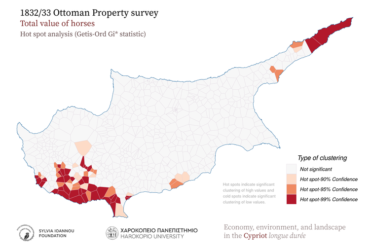
1833, Horses, Hot spot analysis (Getis-Ord Gi* statistic)
1832/33 Ottoman Property survey Total value of horses Hot spot analysis (Getis-Ord Gi* statistic) Hot spots indicate significant clustering of high values and cold spots indicate significant clustering of low values. kuruş Harokopio University Sylvia Ioannou foundation Economy, environment, and landscape in the Cypriot longue durée
1833, Horses, Aggregated in various regions of the island
1832/33 Ottoman Property survey Total value of horses Aggregated in 1885 subdistricts Subdistricts 1885 (Kitchener's map) Modern districts Height zones Geographic regions kuruş Harokopio University Sylvia Ioannou foundation Economy, environment, and landscape in the Cypriot longue durée
1833, Horses, Aggregated in major drainage basins
1832/33 Ottoman Property survey Total value of horses Aggregated in major drainage basins kuruş Harokopio University Sylvia Ioannou foundation Economy, environment, and landscape in the Cypriot longue durée
1833, Horses, Thiessen polygons
1832/33 Ottoman Property survey Total value of horses Thiessen polygons Gray areas indicate zero values for the variable. Comma in the legend is used as thousands separator kuruş Harokopio University Sylvia Ioannou foundation Economy, environment, and landscape in the Cypriot longue durée
1833, Horses, Spatial autocorrelation (Moran's I statistic)
1832/33 Ottoman Property survey Total value of horses Spatial autocorrelation (Moran's I) A high-high cluster is an area with high value surrounded by areas with high values. LISA: Local Indicators οf Spatial Association kuruş Harokopio University Sylvia Ioannou foundation Economy, environment, and landscape in the Cypriot longue durée
1833, Horses, Aggregated in 25 sq.km hexagons
1832/33 Ottoman Property survey Total value of horses Aggregated in 25 Km^2 hexagons Comma in the legend is used as thousands separator kuruş Harokopio University Sylvia Ioannou foundation Economy, environment, and landscape in the Cypriot longue durée
1833, Horses, Aggregated in 25 sq.km rectangles
1832/33 Ottoman Property survey Total value of horses Aggregated in 25 Km^2 rectangles Comma in the legend is used as thousands separator kuruş Harokopio University Sylvia Ioannou foundation Economy, environment, and landscape in the Cypriot longue durée
1833, Horses, Kernel density
1832/33 Ottoman Property survey Total value of horses Kernel density Shades of red color indicate high density of the mapped variable kuruş Harokopio University Sylvia Ioannou foundation Economy, environment, and landscape in the Cypriot longue durée

Sheep and goat

1833, Sheep and goat, Proportional symbols
1832/33 Ottoman Property survey Total value of sheep and goat Proportional symbols Symbol size is relative to the magnitude of each feature attribute. kuruş Harokopio University Sylvia Ioannou foundation Economy, environment, and landscape in the Cypriot longue durée
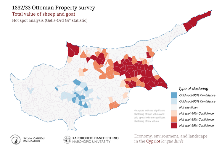
1833, Sheep and goat, Hot spot analysis (Getis-Ord Gi* statistic)
1832/33 Ottoman Property survey Total value of sheep and goat Hot spot analysis (Getis-Ord Gi* statistic) Hot spots indicate significant clustering of high values and cold spots indicate significant clustering of low values. kuruş Harokopio University Sylvia Ioannou foundation Economy, environment, and landscape in the Cypriot longue durée
1833, Sheep and goat, Aggregated in various regions of the island
1832/33 Ottoman Property survey Total value of sheep and goat Aggregated in 1885 subdistricts Subdistricts 1885 (Kitchener's map) Modern districts Height zones Geographic regions kuruş Harokopio University Sylvia Ioannou foundation Economy, environment, and landscape in the Cypriot longue durée
1833, Sheep and goat, Aggregated in major drainage basins
1832/33 Ottoman Property survey Total value of sheep and goat Aggregated in major drainage basins kuruş Harokopio University Sylvia Ioannou foundation Economy, environment, and landscape in the Cypriot longue durée
1833, Sheep and goat, Thiessen polygons
1832/33 Ottoman Property survey Total value of sheep and goat Thiessen polygons Gray areas indicate zero values for the variable. Comma in the legend is used as thousands separator kuruş Harokopio University Sylvia Ioannou foundation Economy, environment, and landscape in the Cypriot longue durée
1833, Sheep and goat, Spatial autocorrelation (Moran's I statistic)
1832/33 Ottoman Property survey Total value of sheep and goat Spatial autocorrelation (Moran's I) A high-high cluster is an area with high value surrounded by areas with high values. LISA: Local Indicators οf Spatial Association kuruş Harokopio University Sylvia Ioannou foundation Economy, environment, and landscape in the Cypriot longue durée
1833, Sheep and goat, Aggregated in 25 sq.km hexagons
1832/33 Ottoman Property survey Total value of sheep and goat Aggregated in 25 Km^2 hexagons Comma in the legend is used as thousands separator kuruş Harokopio University Sylvia Ioannou foundation Economy, environment, and landscape in the Cypriot longue durée
1833, Sheep and goat, Aggregated in 25 sq.km rectangles
1832/33 Ottoman Property survey Total value of sheep and goat Aggregated in 25 Km^2 rectangles Comma in the legend is used as thousands separator kuruş Harokopio University Sylvia Ioannou foundation Economy, environment, and landscape in the Cypriot longue durée
1833, Sheep and goat, Kernel density
1832/33 Ottoman Property survey Total value of sheep and goat Kernel density Shades of red color indicate high density of the mapped variable kuruş Harokopio University Sylvia Ioannou foundation Economy, environment, and landscape in the Cypriot longue durée

Watermills

1833, Watermills, Proportional symbols
1832/33 Ottoman Property survey Total value of Watermills Proportional symbols Symbol size is relative to the magnitude of each feature attribute. kuruş Harokopio University Sylvia Ioannou foundation Economy, environment, and landscape in the Cypriot longue durée
1833, Watermills, Hot spot analysis (Getis-Ord Gi* statistic)
1832/33 Ottoman Property survey Total value of Watermills Hot spot analysis (Getis-Ord Gi* statistic) Hot spots indicate significant clustering of high values and cold spots indicate significant clustering of low values. kuruş Harokopio University Sylvia Ioannou foundation Economy, environment, and landscape in the Cypriot longue durée
1833, Watermills, Aggregated in various regions of the island
1832/33 Ottoman Property survey Total value of Watermills Aggregated in 1885 subdistricts Subdistricts 1885 (Kitchener's map) Modern districts Height zones Geographic regions kuruş Harokopio University Sylvia Ioannou foundation Economy, environment, and landscape in the Cypriot longue durée
1833, Watermills, Aggregated in major drainage basins
1832/33 Ottoman Property survey Total value of Watermills Aggregated in major drainage basins kuruş Harokopio University Sylvia Ioannou foundation Economy, environment, and landscape in the Cypriot longue durée
1833, Watermills, Thiessen polygons
1832/33 Ottoman Property survey Total value of Watermills Thiessen polygons Gray areas indicate zero values for the variable. Comma in the legend is used as thousands separator kuruş Harokopio University Sylvia Ioannou foundation Economy, environment, and landscape in the Cypriot longue durée
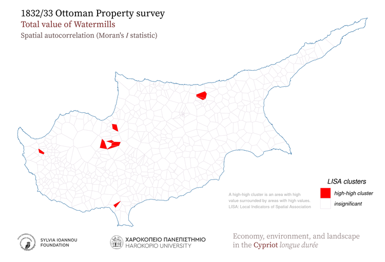
1833, Watermills, Spatial autocorrelation (Moran's I statistic)
1832/33 Ottoman Property survey Total value of Watermills Spatial autocorrelation (Moran's I) A high-high cluster is an area with high value surrounded by areas with high values. LISA: Local Indicators οf Spatial Association kuruş Harokopio University Sylvia Ioannou foundation Economy, environment, and landscape in the Cypriot longue durée
1833, Watermills, Aggregated in 25 sq.km hexagons
1832/33 Ottoman Property survey Total value of Watermills Aggregated in 25 Km^2 hexagons Comma in the legend is used as thousands separator kuruş Harokopio University Sylvia Ioannou foundation Economy, environment, and landscape in the Cypriot longue durée
1833, Watermills, Aggregated in 25 sq.km rectangles
1832/33 Ottoman Property survey Total value of Watermills Aggregated in 25 Km^2 rectangles Comma in the legend is used as thousands separator kuruş Harokopio University Sylvia Ioannou foundation Economy, environment, and landscape in the Cypriot longue durée
1833, Watermills, Kernel density
1832/33 Ottoman Property survey Total value of Watermills Kernel density Shades of red color indicate high density of the mapped variable kuruş Harokopio University Sylvia Ioannou foundation Economy, environment, and landscape in the Cypriot longue durée